GOES satellite sees a triple header in the tropics
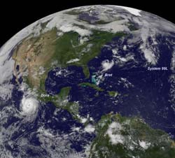
This visible image from the GOES-13 satellite on July 20 at 14:45 UTC (10:45 a.m. EDT) and shows a consolidating System 99L (far right) in the eastern North Atlantic Ocean, Tropical Storm Bret about 255 miles east of Cape Hatteras, N.C., and a large Hurricane Dora off the west coast of Mexico. Credit: NASA/NOAA GOES Project, Dennis Chesters<br>
The GOES-13 satellite captured a triple-header in the tropics today when it captured three tropical cyclones in one image in the Northern Hemisphere.
A visible image taken from the GOES-13 satellite on July 20 at 14:45 UTC (10:45 a.m. EDT) and shows a consolidating low pressure area called System 99L in the eastern North Atlantic Ocean, Tropical Storm Bret several hundred miles east of South Carolina, and a large Hurricane Dora off the west coast of Mexico. The image was created by the NASA/NOAA GOES Project at NASA's Goddard Space Flight Center in Greenbelt, Md.
System 99L is a low pressure area that may to reach tropical depression status in the next day or two. It is located about 550 miles east-northeast of Bermuda and is moving to the northeast at 20 mph.
At 2 p.m. EDT on July 20, satellite imagery showed that showers and thunderstorms have become better organized within System 99L. The low-level circulation is also becoming better defined and the storm appears primed to become a tropical depression. If that happens, it would be Tropical Depression 3 (TD3) in the Atlantic Ocean basin. The National Hurricane Center gives it a 90 percent chance of coming together as TD3 in the next 48 hours.
NASA's Hurricane page: www.nasa.gov/hurricane, also on Facebook and Twitter
Media Contact
All latest news from the category: Earth Sciences
Earth Sciences (also referred to as Geosciences), which deals with basic issues surrounding our planet, plays a vital role in the area of energy and raw materials supply.
Earth Sciences comprises subjects such as geology, geography, geological informatics, paleontology, mineralogy, petrography, crystallography, geophysics, geodesy, glaciology, cartography, photogrammetry, meteorology and seismology, early-warning systems, earthquake research and polar research.


Newest articles

A universal framework for spatial biology
SpatialData is a freely accessible tool to unify and integrate data from different omics technologies accounting for spatial information, which can provide holistic insights into health and disease. Biological processes…

How complex biological processes arise
A $20 million grant from the U.S. National Science Foundation (NSF) will support the establishment and operation of the National Synthesis Center for Emergence in the Molecular and Cellular Sciences (NCEMS) at…

Airborne single-photon lidar system achieves high-resolution 3D imaging
Compact, low-power system opens doors for photon-efficient drone and satellite-based environmental monitoring and mapping. Researchers have developed a compact and lightweight single-photon airborne lidar system that can acquire high-resolution 3D…

