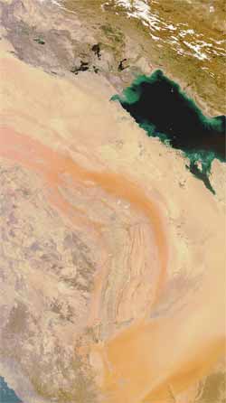
Satellite captures images of sandstorm
The animation shows two cloud-free images of the region: the first captured on 10 March and the second on 18 March.
The latest image shows how sand has swept over the Persian Gulf States in recent days, extending some 1500 km north to south.
Over the past few days, strong winds have whipped up dust and sand, causing low visibility and grounding flights across the region.
In some areas of Saudi Arabia, schools have been closed and hundreds of people are suffering from respiratory problems. The storm has also caused a sharp decline in temperatures.
The storm has even disrupted traffic further south in the United Arab Emirates, Kuwait, Oman and Yemen.
These images were captured by Envisat’s MERIS instrument. This month, Envisat celebrated ten years in orbit.
Media Contact
All latest news from the category: Earth Sciences
Earth Sciences (also referred to as Geosciences), which deals with basic issues surrounding our planet, plays a vital role in the area of energy and raw materials supply.
Earth Sciences comprises subjects such as geology, geography, geological informatics, paleontology, mineralogy, petrography, crystallography, geophysics, geodesy, glaciology, cartography, photogrammetry, meteorology and seismology, early-warning systems, earthquake research and polar research.


Newest articles

A universal framework for spatial biology
SpatialData is a freely accessible tool to unify and integrate data from different omics technologies accounting for spatial information, which can provide holistic insights into health and disease. Biological processes…

How complex biological processes arise
A $20 million grant from the U.S. National Science Foundation (NSF) will support the establishment and operation of the National Synthesis Center for Emergence in the Molecular and Cellular Sciences (NCEMS) at…

Airborne single-photon lidar system achieves high-resolution 3D imaging
Compact, low-power system opens doors for photon-efficient drone and satellite-based environmental monitoring and mapping. Researchers have developed a compact and lightweight single-photon airborne lidar system that can acquire high-resolution 3D…

