UK e-Science project discovers new knowledge about earthquakes
A UK e-Science project is revealing new scientific insights into earthquakes. Technologies developed under the Discovery Net project are enabling geophysicists to combine two different methods of studying earthquakes and so discover new knowledge that would not have been revealed using one method alone.
A previously unsuspected secondary fault associated with an earthquake in the Kunlun Mountains in South-West China has already come to light. Discovery Net was one of six finalists in the HPC Analytics Challenge at the SC05 supercomputing conference in Seattle last week.
One of the methods uses satellite images to reveal land movement on scales from tens of metres to hundreds of kilometres – the ‘macro’ view. The other uses finite element analysis to model the response of brick-sized volumes of rock to stresses and strains and then add them up to build a picture of likely land movement in the event of an earthquake – the ’micro’ view. Finite element analysis is often used to predict earthquake damage to buildings.
Discovery Net researchers at Imperial College, London, have combined these two approaches using InforSense KDE, a workflow-based integrative analytics platform originally developed under Discovery Net and brought to the commercial market by InforSense, a spin-out company from the Department of Computer Science at Imperial College.
For the macro view, they used satellite images of a large earthquake that occurred in an uninhabited region of the eastern Kunlun mountains in China in 2001. Civil engineers from the University of Oklahoma, US did the finite element analysis to give the micro view.
“We wanted to look at the same problem from different perspectives and bridge the gap so we would know how our models translated to their models,” says Dr Moustafa Ghanem from Imperial College. “We wanted to show how workflow analytics can be used to rapidly combine research techniques which, until recently, were impossible to combine.”
InforSense KDE enables researchers to bridge such gaps by building complex analytic workflows that integrate access to data, software and other services held remotely. Workflows can be stored and audited for re-use by the originator or others via web services, portlets or other visual desktop applications.
“Before Discovery Net, you would have to move the output from one analysis to the next by saving it in a file and moving it to another machine. Now, you can run analyses with complex analytic workflows that coordinate the execution of distributed services. Using grid technologies, the data and analytic components used in the data mining – and the workflows themselves – can be distributed all over the world,” says Dr Ghanem.
The initial input into the Kunlun earthquake analysis was a map of land displacement which the Discovery Net team had generated from satellite images taken before and after the quake. The Oklahoma team used this map to create the initial conditions for their finite element analysis and then to modify their model until it produced the deformation actually seen in a small area of the earthquake region.
“With the refined model, we were able to predict the secondary fault and then find it in the images. We couldn’t have done this with the image analysis alone – but we could when we combined it with the microanalysis,” says Dr Ghanem.
Further use of Discovery Net technology for geohazard modelling could be used to build up a comprehensive geological fault line map of the earth, with areas of elevated tension detailed and annotated with models from research groups from all over the world, say the Discovery Net team.
Contacts
Dr Moustafa Ghanem, Imperial College London tel. 07961 133720, e-mail: mmg@doc.ic.ac.uk
Professor Yike Guo, Imperial College London tel. 020 594 8335, e-mail: yg@doc.ic.ac.uk
Judy Redfearn, e-Science/e-research Communications Officer, EPSRC, tel. 07768 356309, e-mail: judy.redfearn@epsrc.ac.uk
Media Contact
All latest news from the category: Earth Sciences
Earth Sciences (also referred to as Geosciences), which deals with basic issues surrounding our planet, plays a vital role in the area of energy and raw materials supply.
Earth Sciences comprises subjects such as geology, geography, geological informatics, paleontology, mineralogy, petrography, crystallography, geophysics, geodesy, glaciology, cartography, photogrammetry, meteorology and seismology, early-warning systems, earthquake research and polar research.


Newest articles

Simplified diagnosis of rare eye diseases
Uveitis experts provide an overview of an underestimated imaging technique. Uveitis is a rare inflammatory eye disease. Posterior and panuveitis in particular are associated with a poor prognosis and a…
Targeted use of enfortumab vedotin for the treatment of advanced urothelial carcinoma
New study identifies NECTIN4 amplification as a promising biomarker – Under the leadership of PD Dr. Niklas Klümper, Assistant Physician at the Department of Urology at the University Hospital Bonn…
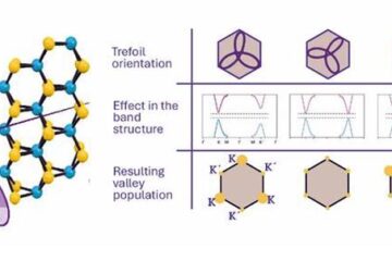
A novel universal light-based technique
…to control valley polarization in bulk materials. An international team of researchers reports in Nature a new method that achieves valley polarization in centrosymmetric bulk materials in a non-material-specific way…

