NASA spots another Arabian Sea tropical cyclone forming
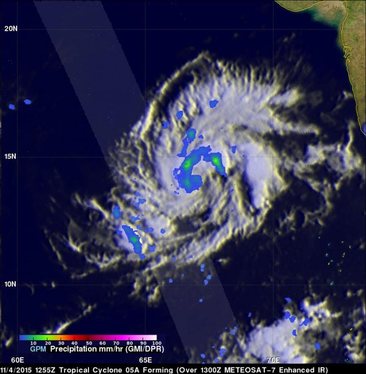
NASA/JAXA's GPM satellite measured scattered light to moderate rainfall in Tropical Cyclone 05A on Nov. 4, falling at a maximum rate of only 23.3 mm (.92 inches) per hour. Credits: NASA/JAXA/SSAI, Hal Pierce
Deadly tropical cyclone Chapala had just dissipated over Yemen when tropical cyclone 05A started forming in the warm waters of the Arabian Sea west of India.
GPM measured the rainfall within the forming tropical cyclone using the satellite's Microwave Imager (GMI) and Dual-Frequency Precipitation Radar (DPR) instruments. GMI and DPR found that 05A had scattered light to moderate rainfall falling at a maximum rate of only 23.3 mm (.92 inches) per hour.
GPM is an international mission led by NASA and the Japan Aerospace Exploration Agency to observe rainfall and snowfall around the world. The program is managed by NASA's Goddard Space Flight Center in Greenbelt, Maryland.
On November 5, 2015 at 1500 UTC (10 a.m. EST), Tropical Cyclone 05A was located near 13.9 degrees north latitude and 63.9 degrees east longitude, about 546 nautical miles (628.7 miles/ 1,012 km) east of Socotra Island, Yemen.
Tropical Cyclone 05A is moving to the west at 10 knots (11.5 mph/18.5 kph). It is a tropical storm with maximum sustained winds near 35 knots (40 mph/64.8 kph).
The tropical storm is expected to track over the island of Socotra on Nov. 8 with tropical storm force winds while heading west.
The Joint Typhoon Warning Center (JTWC) predicts that 05A will head toward Cape Gardafui, Somalia, move into the Gulf of Aden and make landfall in southeastern Yemen north of Aden, Yemen on Nov. 10.
Media Contact
All latest news from the category: Earth Sciences
Earth Sciences (also referred to as Geosciences), which deals with basic issues surrounding our planet, plays a vital role in the area of energy and raw materials supply.
Earth Sciences comprises subjects such as geology, geography, geological informatics, paleontology, mineralogy, petrography, crystallography, geophysics, geodesy, glaciology, cartography, photogrammetry, meteorology and seismology, early-warning systems, earthquake research and polar research.


Newest articles
Economies take off with new airports
A global study by an SUTD researcher in collaboration with scientists from Japan explores the economic benefits of airport investment in emerging economies using nighttime satellite imagery. Be it for…
CAR T–cell immunotherapy targets
Pan-cancer analysis uncovers a new class of promising CAR T–cell immunotherapy targets. Scientists at St. Jude Children’s Research Hospital found 156 potential CAR targets across the brain and solid tumors,…
Stony coral tissue loss disease
… is shifting the ecological balance of Caribbean reefs. The outbreak of a deadly disease called stony coral tissue loss disease is destroying susceptible species of coral in the Caribbean…

