NASA Sees Tropical Storm Polo Intensifying
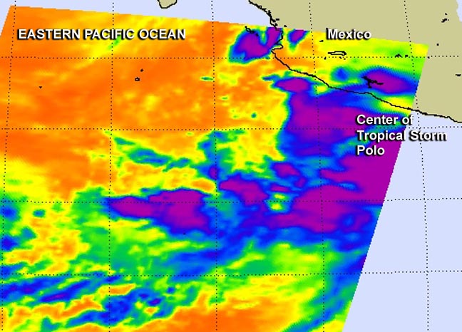
NASA's Aqua satellite passed over Polo on Sept. 17 at 4:59 a.m. EDT and the Atmospheric Infrared Sounder instrument captured infrared data on the storm revealing bands of strong thunderstorms north and south of the center. Image Credit: NASA JPL, Ed Olsen
A Tropical Storm Warning is in force for the southwest coast of Mexico from Punta San Telmo to Playa Perula. A Tropical Storm Watch is in force from Punta San Telmo to Zihuatanejo and from Playa Perula to Cabo Corrientes.
Rainfall totals of 5 to 10, locally up to 15 inches, can be expected over coastal areas of Michoacan, Colima and Jalisco states in Mexico. Life-threatening flash-floods and mudslides could result.
Dangerous ocean swells from the tropical storm are expected to affect the coast of southern Mexico also causing rip-tides.
NASA's Aqua satellite passed over Polo on Sept. 17 at 4:59 a.m. EDT and the Atmospheric Infrared Sounder instrument captured infrared data on the storm revealing bands of strong thunderstorms north and south of the center.
At 11 a.m. EDT on Sept. 17, Polo's maximum sustained winds increased to near 60 mph (95 kph) and the storm is expected to become a hurricane tonight or early Thursday. The center of Tropical Storm Polo was located near latitude 15.7 north. and longitude 102.4 west.
Polo is moving toward the northwest near 10 mph (17 kph) and this motion is expected to continue for the next two days. The National Hurricane Center noted that on the forecast track the core of Polo will remain offshore of and move parallel to the southwestern coast of Mexico.
However, any deviation could bring stronger winds to the coast.
Polo is forecast to become a hurricane in a day or two.
Rob Gutro
NASA's Goddard Space Flight Center
Media Contact
More Information:
http://www.nasa.gov/content/goddard/polo-eastern-pacific/All latest news from the category: Earth Sciences
Earth Sciences (also referred to as Geosciences), which deals with basic issues surrounding our planet, plays a vital role in the area of energy and raw materials supply.
Earth Sciences comprises subjects such as geology, geography, geological informatics, paleontology, mineralogy, petrography, crystallography, geophysics, geodesy, glaciology, cartography, photogrammetry, meteorology and seismology, early-warning systems, earthquake research and polar research.


Newest articles

A universal framework for spatial biology
SpatialData is a freely accessible tool to unify and integrate data from different omics technologies accounting for spatial information, which can provide holistic insights into health and disease. Biological processes…

How complex biological processes arise
A $20 million grant from the U.S. National Science Foundation (NSF) will support the establishment and operation of the National Synthesis Center for Emergence in the Molecular and Cellular Sciences (NCEMS) at…

Airborne single-photon lidar system achieves high-resolution 3D imaging
Compact, low-power system opens doors for photon-efficient drone and satellite-based environmental monitoring and mapping. Researchers have developed a compact and lightweight single-photon airborne lidar system that can acquire high-resolution 3D…

