NASA sees Tropical Storm Kate form, Bahamas under warning
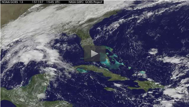
This 43 second animation of infrared and visible imagery from NOAA's GOES-East satellite from Nov. 7-9 shows the development and movement of Tropical Storm Kate to the Bahamas. Credits: NASA/NOAA GOES Project
On November 9, 2015 a Tropical Storm Warning was in effect for the central and northwestern Bahamas.
On Nov. 8, 2015 the Moderate Resolution Imaging Spectroradiometer or MODIS instrument aboard NASA's Terra satellite captured a visible image of newborn Tropical Depression 12 in the western Atlantic. Kate formed as a tropical depression at 10 p.m. EST on Nov. 8 about 115 miles (190 km) southeast of San Salvador.
At 8:20 a.m. EST, Air Force Reserve hurricane hunter aircraft data indicated that Tropical Depression Twelve has strengthened to Tropical Storm Kate. The maximum sustained winds at that time were estimated to be 40 mph (65 kph) with higher gusts.
A 43 second animation of infrared and visible imagery from NOAA's GOES-East satellite over the period of satellite from Nov. 7 to 9 shows the development and movement of Tropical Storm Kate to the Bahamas. The animation was created by the NASA/NOAA GOES Project at NASA Goddard.
At 10 a.m. EST (1500 UTC) on November 9, 2015 the center of Tropical Storm Kate was located near latitude 24.5 North, longitude 75.3 West. That's just 15 miles (25 km) east-northeast of Cat Island an about 170 miles (275 km) southeast of Great Abaco Island.
Kate was moving toward the northwest near 15 mph (24 kph). The National Hurricane Center (NHC) expects Kate to turn toward the north, followed by a turn toward the north-northeast on Tuesday, November 10. Maximum sustained winds had increased to near 45 mph (75 kph) and additional strengthening is forecast during the next two days. The estimated minimum central pressure based on data from an Air Force Reserve reconnaissance aircraft is 1008 millibars.
Because the central and northwestern Bahamas are under a tropical storm warning, the National Hurricane Center said total rain accumulations of 1 to 3 inches over the Bahamas through tonight, November 3.
###
For updates on the forecast track of Kate, please visit the NHC website: http://www.
Media Contact
All latest news from the category: Earth Sciences
Earth Sciences (also referred to as Geosciences), which deals with basic issues surrounding our planet, plays a vital role in the area of energy and raw materials supply.
Earth Sciences comprises subjects such as geology, geography, geological informatics, paleontology, mineralogy, petrography, crystallography, geophysics, geodesy, glaciology, cartography, photogrammetry, meteorology and seismology, early-warning systems, earthquake research and polar research.


Newest articles

A universal framework for spatial biology
SpatialData is a freely accessible tool to unify and integrate data from different omics technologies accounting for spatial information, which can provide holistic insights into health and disease. Biological processes…

How complex biological processes arise
A $20 million grant from the U.S. National Science Foundation (NSF) will support the establishment and operation of the National Synthesis Center for Emergence in the Molecular and Cellular Sciences (NCEMS) at…

Airborne single-photon lidar system achieves high-resolution 3D imaging
Compact, low-power system opens doors for photon-efficient drone and satellite-based environmental monitoring and mapping. Researchers have developed a compact and lightweight single-photon airborne lidar system that can acquire high-resolution 3D…

