NASA sees Tropical Storm Helen affecting southeastern India
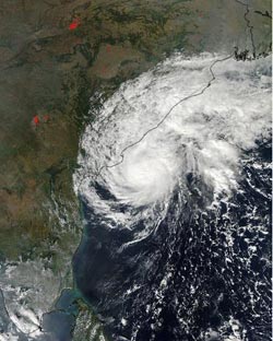
On Nov. 21 at 07:55 UTC the MODIS instrument aboard NASA's Aqua satellite captured this visible image of Tropical Cyclone Helen over eastern India.<br><br>Credit: NASA Goddard MODIS Rapid Response Team<br>
On Nov. 21 at 07:55 UTC/2:55 a.m. EDT the MODIS or Moderate Resolution Imaging Spectroradiometer instrument that flies aboard NASA's Aqua satellite captured a visible image of Tropical Cyclone Helen that showed clouds in the storm's western quadrant had already spread over eastern India.
Two minutes before the MODIS instrument captured the visible image of Helen's clouds, the infrared instrument aboard Aqua called the Atmospheric Infrared Sounder or AIRS instrument used infrared light to gather data from the storm. The infrared data showed that the strongest thunderstorms with the coldest cloud top temperatures were still off-shore.
The stretched around the center from northwest to southwest and wrapped around to the east. Only the bands of thunderstorms in the northern quadrant appeared to be fragmented, which could be a result of that area's interaction with land.
On Nov. 21 at 1500 UTC/10 a.m. EST, Tropical Cyclone Helen was located about 495 nautical miles/569.6 miles/ 916.7 km southwest of Calcutta, India, near 16.1 north and 83.0 east. Helen was moving a little faster than the previous day, now at 4 knots/4.6 mph/7.4 kph to the northwest. Helen's maximum sustained winds had increased slightly to 55 knots/63.2 mph/101.9 kph, and those tropical storm force winds extend out 65 nautical miles/74.8 miles/120.4 km from the center. Helen was also creating maximum wave heights of up to 20 feet/6.0 meters, and causing rough seas along the southwestern coast of India.
As a result of the strong waves and tropical-storm force winds, warnings are in effect for Andhra Pradesh that include: A storm surge of 1 to 1.5 meters/3.2 to 4.9 feet will occur at the time of landfall, Thatched roofs and huts will sustain damage and a call for fisheries to cease operations.
Helen is expected to weaken as it nears the coast as it moves into cooler waters and continues to battle moderate wind shear. Helen is expected to make landfall near Tenali early on November 22. After landfall, Helen should weaken as it moves west where it is expected to dissipate in a couple of days.
Media Contact
More Information:
http://www.nasa.govAll latest news from the category: Earth Sciences
Earth Sciences (also referred to as Geosciences), which deals with basic issues surrounding our planet, plays a vital role in the area of energy and raw materials supply.
Earth Sciences comprises subjects such as geology, geography, geological informatics, paleontology, mineralogy, petrography, crystallography, geophysics, geodesy, glaciology, cartography, photogrammetry, meteorology and seismology, early-warning systems, earthquake research and polar research.


Newest articles

A universal framework for spatial biology
SpatialData is a freely accessible tool to unify and integrate data from different omics technologies accounting for spatial information, which can provide holistic insights into health and disease. Biological processes…

How complex biological processes arise
A $20 million grant from the U.S. National Science Foundation (NSF) will support the establishment and operation of the National Synthesis Center for Emergence in the Molecular and Cellular Sciences (NCEMS) at…

Airborne single-photon lidar system achieves high-resolution 3D imaging
Compact, low-power system opens doors for photon-efficient drone and satellite-based environmental monitoring and mapping. Researchers have developed a compact and lightweight single-photon airborne lidar system that can acquire high-resolution 3D…

