NASA sees Tropical Storm Gaemi's heaviest rainfall around center
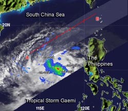
When NASA's TRMM satellite passed over Tropical Storm Gaemi on Oct. 3 at 1241 UTC (8:41 a.m. EDT), light rainfall (blue) was occurring over most of the storm. Moderate rain (green and orange) was falling at a rate between .78 to 1.57 inches/20 to 40 mm per hour and surrounded a small area of heavy rainfall (red) circling tightly around the center. The heaviest rain was falling at 2 inches (50 mm) per hour.<br><br>Credit: SSAI/NASA, Hal Pierce<br>
When NASA's Tropical Rainfall Measuring Mission (TRMM) satellite passed over Tropical Storm Gaemi on Oct. 3 at 1241 UTC (8:41 a.m. EDT), the precipitation radar instrument detected light rainfall occurring over most of the storm. Moderate rain was falling at a rate between .78 to 1.57 inches/20 to 40 mm per hour and surrounded a small area of heavy rainfall circling tightly around the around the center. The heaviest rain was falling at 2 inches (50 mm) per hour.
Satellite imagery on Oct. 4 shows that wind shear is taking a toll on the storm, pushing the bulk of the showers to the west, by strong easterly winds. The center of circulation also appears to be fully exposed to outside winds, which leaves the storm wide open for additional weakening influences.
On Tuesday, Oct. 3, 2012 at 1500 UTC (11 a.m. EDT), Tropical storm Gaemi had maximum sustained winds near 35 knots (40 mph/65 kph). It was located 605 nautical miles (696 miles/1,120 km) east of Hue, Vietnam near 14.7 North latitude and 117.7 East longitude. Gaemi was moving to the west at 2 knots (2.3 mph/3.7 kph).
Gaemi is expected to start moving around an area of high pressure nearby strengthens, which would push the storm west toward Vietnam. Gaemi is forecast to make landfall south of Hue, Vietnam sometime on Oct. 6. As the storm nears coastal conditions will deteriorate.
Media Contact
More Information:
http://www.nasa.govAll latest news from the category: Earth Sciences
Earth Sciences (also referred to as Geosciences), which deals with basic issues surrounding our planet, plays a vital role in the area of energy and raw materials supply.
Earth Sciences comprises subjects such as geology, geography, geological informatics, paleontology, mineralogy, petrography, crystallography, geophysics, geodesy, glaciology, cartography, photogrammetry, meteorology and seismology, early-warning systems, earthquake research and polar research.


Newest articles

A universal framework for spatial biology
SpatialData is a freely accessible tool to unify and integrate data from different omics technologies accounting for spatial information, which can provide holistic insights into health and disease. Biological processes…

How complex biological processes arise
A $20 million grant from the U.S. National Science Foundation (NSF) will support the establishment and operation of the National Synthesis Center for Emergence in the Molecular and Cellular Sciences (NCEMS) at…

Airborne single-photon lidar system achieves high-resolution 3D imaging
Compact, low-power system opens doors for photon-efficient drone and satellite-based environmental monitoring and mapping. Researchers have developed a compact and lightweight single-photon airborne lidar system that can acquire high-resolution 3D…

