NASA sees Tropical Cyclone's Hellen's lively remnants
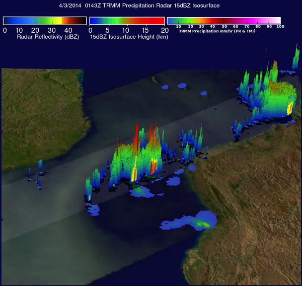
The TRMM satellite flew over Hellen's remnants in the Mozambique Channel on April 2, 2014 at 0143 UTC and saw some thunderstorms topped out near 9.9 miles high. Image Credit: SSAI/NASA, Hal Pierce
A rainfall analysis using the Tropical Rainfall Measuring Mission's (TRMM) Microwave Imager (TMI) and Precipitation Radar (PR) instruments found that some strong convective thunderstorms had developed in the area.
It was revealed by TRMM PR data that rain was falling at a rate of over 75 mm/~ 3 inches in a few locations.
TRMM's Precipitation Radar (PR) data were used to create a 3-D image that showed the structure in the convective thunderstorms near the center of Hellen's remnants.
The 3-D view showed that a few of these tall thunderstorms were reaching heights of over 16 km/9.9 miles.
At 1800 UTC/2:00 p.m. EDT on April 1, the center of Hellen's remnants were located near 18.3 south and 42.3 east, about 271 nautical miles/311.9 miles/501.9 km west of Antananarivo, Madagascar.
Maximum sustained winds were estimated as high as 25 knots/28.7 mph/46.3 kph, and minimum sea level pressure was near 1004 millibars. The low-level circulation center appeared slightly elongated and the convection and thunderstorm development is disorganized.
The Joint Typhoon Warning Center expects the remnant low to move on a westward track toward Mozambique over the next couple of days. The system has a low chance of regenerating in the next 24 hours.
Text credit: Hal Pierce/Rob Gutro
SSAI/NASA's Goddard Space Flight Center
Media Contact
All latest news from the category: Earth Sciences
Earth Sciences (also referred to as Geosciences), which deals with basic issues surrounding our planet, plays a vital role in the area of energy and raw materials supply.
Earth Sciences comprises subjects such as geology, geography, geological informatics, paleontology, mineralogy, petrography, crystallography, geophysics, geodesy, glaciology, cartography, photogrammetry, meteorology and seismology, early-warning systems, earthquake research and polar research.


Newest articles

A universal framework for spatial biology
SpatialData is a freely accessible tool to unify and integrate data from different omics technologies accounting for spatial information, which can provide holistic insights into health and disease. Biological processes…

How complex biological processes arise
A $20 million grant from the U.S. National Science Foundation (NSF) will support the establishment and operation of the National Synthesis Center for Emergence in the Molecular and Cellular Sciences (NCEMS) at…

Airborne single-photon lidar system achieves high-resolution 3D imaging
Compact, low-power system opens doors for photon-efficient drone and satellite-based environmental monitoring and mapping. Researchers have developed a compact and lightweight single-photon airborne lidar system that can acquire high-resolution 3D…

