NASA sees Tropical Cyclone Bruce still wide-eyed
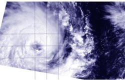
NASA's Terra satellite passed over the center of Tropical Cyclone Bruce on Dec. 19 at 03:40 UTC and the MODIS instrument captured this image, clearly showing an eye.<br><br>Credit: NRL/NASA<br>
The Moderate Resolution Imaging Spectroradiometer instrument known as MODIS takes amazing visible and infrared images of tropical cyclones, among other things, and captured a good look into the eye of Bruce on Dec. 19 at 03:41 UTC.
Although Bruce's eye seemed to have some high clouds, the eye was still visible. Also visible by MODIS were thick bands of thunderstorms wrapping around the storm's northern quadrant. Convection (rising air that forms the thunderstorms that make up a tropical cyclone) was seen strengthening around the eyewall.
On December 19 at 1500 UTC, Tropical Cyclone Bruce's maximum sustained winds were near 90 knots/103.6 mph/166.7 kph. Bruce was centered near 12.7 south and 90.7 east, about 330 nautical miles/379.8 miles/611.1 km west of Cocos Island, Australia. It was moving to the west-southwest at 10 knots/11.5 mph/18.5 kph.
Bruce is moving along the northern edge of an elongated area of subtropical high pressure and is expected to continue moving to the west-southwest for another three days according to the Joint Typhoon Warning Center.
Media Contact
More Information:
http://www.nasa.govAll latest news from the category: Earth Sciences
Earth Sciences (also referred to as Geosciences), which deals with basic issues surrounding our planet, plays a vital role in the area of energy and raw materials supply.
Earth Sciences comprises subjects such as geology, geography, geological informatics, paleontology, mineralogy, petrography, crystallography, geophysics, geodesy, glaciology, cartography, photogrammetry, meteorology and seismology, early-warning systems, earthquake research and polar research.


Newest articles

A universal framework for spatial biology
SpatialData is a freely accessible tool to unify and integrate data from different omics technologies accounting for spatial information, which can provide holistic insights into health and disease. Biological processes…

How complex biological processes arise
A $20 million grant from the U.S. National Science Foundation (NSF) will support the establishment and operation of the National Synthesis Center for Emergence in the Molecular and Cellular Sciences (NCEMS) at…

Airborne single-photon lidar system achieves high-resolution 3D imaging
Compact, low-power system opens doors for photon-efficient drone and satellite-based environmental monitoring and mapping. Researchers have developed a compact and lightweight single-photon airborne lidar system that can acquire high-resolution 3D…

