NASA Sees Tropical Cyclone 15S Form in So. Indian Ocean
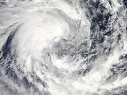
On Feb. 11 at 0805 UTC the MODIS instrument aboard NASA's Aqua satellite captured this visible image of Tropical Cyclone Fifteen (15S) in the Indian Ocean. Credit: NASA Goddard MODIS Rapid Response Team<br>
Tropical Cyclone 15S was born from the low pressure area designated as System 92S. System 92S developed on Feb. 9 and intensified into a tropical storm on Feb. 11 at 0300 UTC. At that time, Tropical Cyclone 15S had maximum sustained winds near 35 knots (40.2 mph/64.8 kph), making it a tropical storm.
It was centered near 12.1 south latitude and 82.5 east longitude, about 650 nautical miles (748 miles/1204 km) east-southeast of Diego Garcia. Tropical Cyclone 15S is far from any land areas and is expected to strengthen and dissipate over open ocean.
On Feb. 11 at 0805 UTC the Moderate Resolution Imaging Spectroradiometer (MODIS) instrument aboard NASA's Aqua satellite captured a visible image of Tropical Cyclone 15S in the Southern Indian Ocean. The image showed that the center of the storm had continued consolidating and was obscured by central dense overcast. Imagery from the special sensor microwave/imager (SSM/I) instrument, a seven-channel, four-frequency passive microwave radiometer system aboard the DMSP satellite showed bands of strong thunderstorms were wrapping into the storm's well-defined center of circulation, an indication that the storm is strengthening.
Tropical Cyclone 15S was moving to the west-southwest at 10 knots (11.5 mph/18.5 kph). The tropical storm is forecast to move to the southwest, then turn south and strengthen to hurricane force within the next two days. The Joint Typhoon Warning Center expects that wind shear and cooler waters will weaken the storm after that time.
Text Credit: Rob Gutro
NASA's Goddard Space Flight Center
Media Contact
All latest news from the category: Earth Sciences
Earth Sciences (also referred to as Geosciences), which deals with basic issues surrounding our planet, plays a vital role in the area of energy and raw materials supply.
Earth Sciences comprises subjects such as geology, geography, geological informatics, paleontology, mineralogy, petrography, crystallography, geophysics, geodesy, glaciology, cartography, photogrammetry, meteorology and seismology, early-warning systems, earthquake research and polar research.


Newest articles

A universal framework for spatial biology
SpatialData is a freely accessible tool to unify and integrate data from different omics technologies accounting for spatial information, which can provide holistic insights into health and disease. Biological processes…

How complex biological processes arise
A $20 million grant from the U.S. National Science Foundation (NSF) will support the establishment and operation of the National Synthesis Center for Emergence in the Molecular and Cellular Sciences (NCEMS) at…

Airborne single-photon lidar system achieves high-resolution 3D imaging
Compact, low-power system opens doors for photon-efficient drone and satellite-based environmental monitoring and mapping. Researchers have developed a compact and lightweight single-photon airborne lidar system that can acquire high-resolution 3D…

