NASA sees rainfall pushed away from Tropical Storm Anais' center
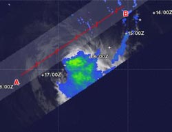
When NASA's TRMM satellite passed over Tropical Storm Anais on Oct. 16 at 0654 UTC (2:54 a.m. EDT), light to moderate rainfall (green and blue) was occurring southeast of the center and falling at a rate between .78 to 1.57 inches/20 to 40 mm per hour. There no areas of heavy rainfall, indicating that the storm had weakened since the previous day.<br><br>Credit: SSAI/NASA, Hal Pierce<br>
When NASA's Tropical Rainfall Measuring Mission (TRMM) satellite passed over Tropical Storm Anais on Oct. 16 at 0654 UTC (2:54 a.m. EDT), light to moderate rainfall was occurring southeast of the center and falling at a rate between .78 to 1.57 inches/20 to 40 mm per hour.
The displacement of rainfall from around the storm's center to the southeast indicates moderate to strong northwesterly wind shear. There no areas of heavy rainfall, indicating that the storm had weakened since the previous day.
Forecasters at the Joint Typhoon Warning Center noted “the TRMM image depicts tightly-curved, shallow convective (thunderstorm) banding wrapping into a well-defined center with deep convective banding limited to the south quadrant.”
Tropical Storm Anais had maximum sustained winds near 55 knots (63.2 mph/102 kph) on Oct. 16 at 1500 UTC (11 a.m. EDT). Anais was located near 14.4 South and 59.8 East, about 500 nautical miles (575 miles/926 km) north-northeast of La Reunion and moving toward the west-southwest at 9 knots (10.3 mph/16.6 kph).
Anais is forecast to continue tracking to the west-southwest toward Madagascar, while weakening.
Media Contact
More Information:
http://www.nasa.govAll latest news from the category: Earth Sciences
Earth Sciences (also referred to as Geosciences), which deals with basic issues surrounding our planet, plays a vital role in the area of energy and raw materials supply.
Earth Sciences comprises subjects such as geology, geography, geological informatics, paleontology, mineralogy, petrography, crystallography, geophysics, geodesy, glaciology, cartography, photogrammetry, meteorology and seismology, early-warning systems, earthquake research and polar research.


Newest articles

A universal framework for spatial biology
SpatialData is a freely accessible tool to unify and integrate data from different omics technologies accounting for spatial information, which can provide holistic insights into health and disease. Biological processes…

How complex biological processes arise
A $20 million grant from the U.S. National Science Foundation (NSF) will support the establishment and operation of the National Synthesis Center for Emergence in the Molecular and Cellular Sciences (NCEMS) at…

Airborne single-photon lidar system achieves high-resolution 3D imaging
Compact, low-power system opens doors for photon-efficient drone and satellite-based environmental monitoring and mapping. Researchers have developed a compact and lightweight single-photon airborne lidar system that can acquire high-resolution 3D…

