NASA sees powerful Typhoon Sanba make landfall
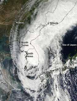
NASA's Aqua satellite passed over Tropical Storm Sanba on Sept. 17 at 0430 UTC and the MODIS instrument captured this visible image of the storm when it was over South and North Korea. Some of Sanba's clouds extended north over eastern Siberia.<br><br>Credit: NASA Goddard MODIS Rapid Response Team<br>
Sanba downed trees, and caused power outages, canceled flights and canceled ferries. NASA's Aqua satellite captured a visible image of Sanba on Sept. 17 after it made landfall and observed the large extent of its cloud cover from South Korea to eastern Siberia.
NASA's Aqua satellite passed over Tropical Storm Sanba on Sept. 17 at 0430 UTC (12:30 a.m. EDT/1:30 p.m. local time Seoul, South Korea) and the Moderate Resolution Imaging Spectroradiometer (MODIS) instrument captured this visible image of the storm when it was over South and North Korea. The image revealed that some of Sanba's clouds extended north over northeastern North Korea and eastern Siberia.
According to the Associated Press, Sanba caused about 67,000 homes to lose power in southern Japan, and over 26,000 outages in South Korea. At least one death was reported.
At 0900 UTC (5 a.m. EDT) on Sept. 17, Sanba had maximum sustained winds near 45 knots (52 mph/83 kmh). It was located about 10 nautical miles northwest of Taegu, South Korea, near 37.2 North and 128.9 East. Since making landfall earlier in the day the storm has sped up and is moving to the north-northeast at 20 knots (23 mph/37 kmh). Surface observations from Taegu at that time indicated maximum sustained winds near 24 knots (27.6 mph/44.4 kmh) with gusts to 40 knots (46 mph/74 kmh).
Sanba is expected to experience some big changes over the next day. It is tracking over the rough terrain of the Taebaek Mountain range and is transitioning into an extra-tropical storm. That means that the core of the system will change from warm to cold.
The Joint Typhoon Warning Center expects Sanba to become a cold core low after its remnants emerge back in the Sea of Japan later today, Sept. 17, if it doesn't dissipate over land.
Media Contact
More Information:
http://www.nasa.govAll latest news from the category: Earth Sciences
Earth Sciences (also referred to as Geosciences), which deals with basic issues surrounding our planet, plays a vital role in the area of energy and raw materials supply.
Earth Sciences comprises subjects such as geology, geography, geological informatics, paleontology, mineralogy, petrography, crystallography, geophysics, geodesy, glaciology, cartography, photogrammetry, meteorology and seismology, early-warning systems, earthquake research and polar research.


Newest articles

A universal framework for spatial biology
SpatialData is a freely accessible tool to unify and integrate data from different omics technologies accounting for spatial information, which can provide holistic insights into health and disease. Biological processes…

How complex biological processes arise
A $20 million grant from the U.S. National Science Foundation (NSF) will support the establishment and operation of the National Synthesis Center for Emergence in the Molecular and Cellular Sciences (NCEMS) at…

Airborne single-photon lidar system achieves high-resolution 3D imaging
Compact, low-power system opens doors for photon-efficient drone and satellite-based environmental monitoring and mapping. Researchers have developed a compact and lightweight single-photon airborne lidar system that can acquire high-resolution 3D…

