NASA Sees Newborn Tropical Storm Hudhud in Northern Indian Ocean
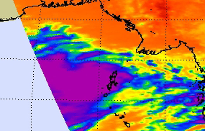
NASA's Aqua satellite passed over Tropical Cyclone Hudhud on Oct. 8 at 6:53 UTC (2:53 a.m. EDT and the Atmospheric Infrared Sounder instrument captured infrared data on the storm revealing bands of strong thunderstorms east of the center. Credit: Image Credit: NASA JPL, Ed Olsen
The Atmospheric Infrared Sounder or AIRS instrument that flies aboard NASA's Aqua satellite passed over Tropical Cyclone Hudhud on Oct. 8 at 6:53 UTC (2:53 a.m. EDT and captured infrared data on the storm revealing bands of strong thunderstorms around the center.
Animated infrared satellite imagery showed that the low-level circulation center was consolidating, and there is an improvement in the banding of thunderstorms wrapping into a defined center.
Another image showed tightly-curved banding of thunderstorms and an eye in microwave data.
On Oct. 8 at 1500 UTC (11 a.m. EDT), Hudhud had maximum sustained winds near 45 knots (51.7 mph/83.3 kph). It was centered near 13.2 north and 90.4 east.
It was centered about 562 nautical miles (646.7 miles/1,041 kph) south of Chittagong, India. Hudhud was moving to the west-northwest at 9 knots (10.3 mph/16.6 kph).
The Joint Typhoon Warning Center expects Hudhud to reach hurricane strength and make landfall near Visakhapatnam on Oct. 10.
Rob Gutro
NASA's Goddard Space Flight Center
Media Contact
All latest news from the category: Earth Sciences
Earth Sciences (also referred to as Geosciences), which deals with basic issues surrounding our planet, plays a vital role in the area of energy and raw materials supply.
Earth Sciences comprises subjects such as geology, geography, geological informatics, paleontology, mineralogy, petrography, crystallography, geophysics, geodesy, glaciology, cartography, photogrammetry, meteorology and seismology, early-warning systems, earthquake research and polar research.


Newest articles

A universal framework for spatial biology
SpatialData is a freely accessible tool to unify and integrate data from different omics technologies accounting for spatial information, which can provide holistic insights into health and disease. Biological processes…

How complex biological processes arise
A $20 million grant from the U.S. National Science Foundation (NSF) will support the establishment and operation of the National Synthesis Center for Emergence in the Molecular and Cellular Sciences (NCEMS) at…

Airborne single-photon lidar system achieves high-resolution 3D imaging
Compact, low-power system opens doors for photon-efficient drone and satellite-based environmental monitoring and mapping. Researchers have developed a compact and lightweight single-photon airborne lidar system that can acquire high-resolution 3D…

