NASA sees heavy rain in Tropical Cyclone Lam
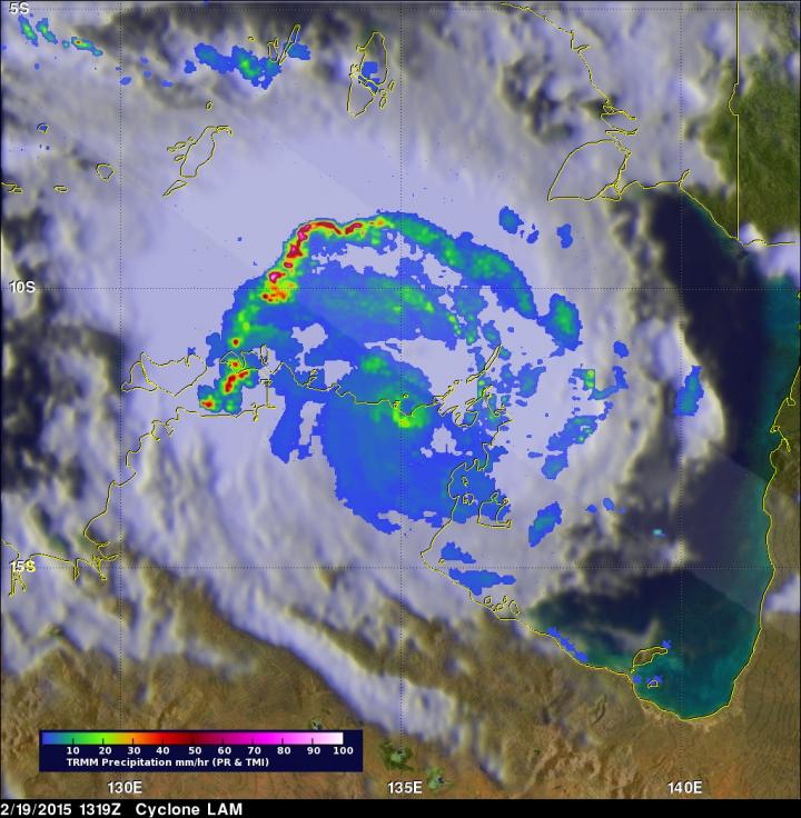
The TRMM satellite saw rainfall in Lam was occurring at 123 mm (4.8 inches) per hour in an intense band of storms over the Timor Sea northwest of the eye. Some thunderstorms topped over 16.7 km (10.4 miles). Image Credit: NASA/JAXA, Hal Pierce
Tropical Cyclone Lam made landfall as a Category Four storm, according to the Australian Bureau of Meteorology (ABM). It came ashore near Elcho and Goulburn Island, east of Darwin.
TRMM passed over Lam on Feb. 19 at 13:19 UTC (8:19 a.m. EST). TRMM's Precipitation Radar (PR) had just been temporarily returned to service when it passed over Lam. The PR instrument found rain falling at an estimated rate of over 123 mm (4.8 inches) per hour in an intense band of storms over the Timor Sea northwest of LAM's eye. Some thunderstorm tops in that area were found reaching heights of over 16.7 km (10.4 miles).
As of Feb. 20, the ABM cancelled the cyclone warning for inland parts of the central Arnhem District. At 4:00 p.m. CST Darwin local time, Lam's sustained winds were near 55 kph.
Lam was centered near 14.1 degrees south and 133.8 degrees east, about 75 km southwest of Bulman, Northern Territory. Lam was speeding to the south-southwest at 21 kph.
ABM noted “Squally thunderstorms are likely to continue over the Top End. Heavy rain is expected to cause flooding of low-lying areas and cause river rises over the central Top End. A Flood Watch for the Arnhem and Carpentaria Coastal Rivers has been issued.” For further updates on local conditions visit the ABM website: http://www.
The TRMM satellite is managed by both NASA and the Japan Aerospace Exploration Agency.
Media Contact
All latest news from the category: Earth Sciences
Earth Sciences (also referred to as Geosciences), which deals with basic issues surrounding our planet, plays a vital role in the area of energy and raw materials supply.
Earth Sciences comprises subjects such as geology, geography, geological informatics, paleontology, mineralogy, petrography, crystallography, geophysics, geodesy, glaciology, cartography, photogrammetry, meteorology and seismology, early-warning systems, earthquake research and polar research.


Newest articles

A universal framework for spatial biology
SpatialData is a freely accessible tool to unify and integrate data from different omics technologies accounting for spatial information, which can provide holistic insights into health and disease. Biological processes…

How complex biological processes arise
A $20 million grant from the U.S. National Science Foundation (NSF) will support the establishment and operation of the National Synthesis Center for Emergence in the Molecular and Cellular Sciences (NCEMS) at…

Airborne single-photon lidar system achieves high-resolution 3D imaging
Compact, low-power system opens doors for photon-efficient drone and satellite-based environmental monitoring and mapping. Researchers have developed a compact and lightweight single-photon airborne lidar system that can acquire high-resolution 3D…

