NASA Sees Eighteenth Atlantic Depression Form
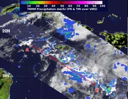
NASA's TRMM satellite flew over the developing tropical depression 18 on Oct. 21 at 8:40 p.m. EDT and noticed a hot towering thunderstorm over 9.3 miles (15 kilometers) high and an area of heavy rainfall (red).<br>Credit: NASA/SSAI, Hal Pierce <br>
When NASA's Tropical Rainfall Measuring Mission (TRMM) satellite flew over the developing TD18 early on Oct. 22 at 0040 UTC (Oct. 21 at 8:40 p.m. EDT), the satellite measured rainfall rates within the low pressure area and measured cloud heights of the thunderstorms that make up the low.
TRMM noticed that the developing depression had a “hot towering” thunderstorm over 9.3 miles (15 kilometers) high. That same area also revealed heavy rainfall where rain was falling at 2 inches/50 mm per hour.
Hot Towers are towering clouds that emit a tremendous amount of latent heat (that's why they're called “hot” towers). NASA research indicates that whenever a hot tower is spotted, a tropical cyclone will likely intensify within 6 or more hours, and the low pressure system intensified into a tropical depression.
Satellite data also showed that the depression also has a closed surface circulation and the banding of thunderstorms around the center has increased during the early morning hours on Oct. 22. These are all signs that the depression is getting more organized.
At 11 a.m. EDT, TD18 had maximum sustained winds near 30 mph (45 kph). It was located near 13.5 North latitude and 78.0 West longitude, about 320 miles (515 km) south-southwest of Kingston, Jamaica. TD18 was moving to the southwest at 5 mph 7 kph) and had a minimum central pressure of 1003 millibars.
The National Hurricane Center (NHC) noted that a tropical storm warning could be needed later in the day on Monday, Oct. 22 for Jamaica. Also, interests in eastern Cuba, Hispaniola, and the Bahamas should monitor the progress of this system. According to NHC, the depression is expected to drift westward and the turn to the north-northeast on Oct. 23 and 24. The forecast track takes TD18's center near Jamaica during the night-time hours on Oct. 23.
Tropical Depression 18 was born from the low pressure area formerly known as System 99L. The NHC expects TD18 to strengthen and become a tropical storm later on Oct. 22 or on Oct. 23. Once the depression becomes a tropical storm it would be renamed “Tropical Storm Sandy.”
In addition to the new tropical depression, there's another area that forecasters are watching in the Atlantic. System 90L is producing showers and thunderstorms in the central Atlantic about 700 miles east-northeast of the Leeward Islands. During the morning hours of Oct. 22, the showers had become a little better organized, and the NHC gives the low a 50 percent chance of becoming the nineteenth tropical depression of the Atlantic hurricane season.
Text credit: Rob Gutro
NASA's Goddard Space Flight Center, Greenbelt, Md.
Media Contact
All latest news from the category: Earth Sciences
Earth Sciences (also referred to as Geosciences), which deals with basic issues surrounding our planet, plays a vital role in the area of energy and raw materials supply.
Earth Sciences comprises subjects such as geology, geography, geological informatics, paleontology, mineralogy, petrography, crystallography, geophysics, geodesy, glaciology, cartography, photogrammetry, meteorology and seismology, early-warning systems, earthquake research and polar research.


Newest articles

A universal framework for spatial biology
SpatialData is a freely accessible tool to unify and integrate data from different omics technologies accounting for spatial information, which can provide holistic insights into health and disease. Biological processes…

How complex biological processes arise
A $20 million grant from the U.S. National Science Foundation (NSF) will support the establishment and operation of the National Synthesis Center for Emergence in the Molecular and Cellular Sciences (NCEMS) at…

Airborne single-photon lidar system achieves high-resolution 3D imaging
Compact, low-power system opens doors for photon-efficient drone and satellite-based environmental monitoring and mapping. Researchers have developed a compact and lightweight single-photon airborne lidar system that can acquire high-resolution 3D…

