NASA Sees Cyclone Irina Weaker in Mozambique Channel
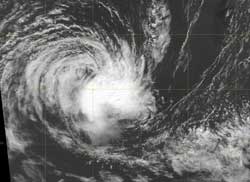
The MODIS instrument on NASA's Aqua satellite captured this visible image of Cyclone Irina on March 9 at 1048 UTC (5:48 a.m. EST). The strongest part of the storm is south of the center, and wind shear is now taking a toll on the storm's strength. Credit: NRL/NASA <br>
On March 8 at 1500 UTC (10 a.m. EST), Irina's winds had finally dropped below 45 knots (51.7 mph/83.3 kph) to 35 knots (40.2 mph/64.8 kph) making it a minimal tropical storm. Irina was still in the southern Mozambique Channel, centered near 29.5 South and 37.8 East. That is about 350 miles southeast of Maputo, Mozambique. Irina is moving to the west at 8 knots (9.2 mph/14.8 kph).
The Moderate Resolution Imaging Spectroradiometer (MODIS) instrument on NASA's Aqua satellite captured this visible image of Cyclone Irina on March 9 at 1048 UTC (5:48 a.m. EST) that showed the bulk of clouds and showers south of the center of circulation, with some outer bands of thunderstorms to the west.
Infrared satellite imagery shows that the strongest thunderstorms, located in the southeastern quadrant have weakened and are being pushed away from the center from wind shear. Once a tropical cyclone is no longer “stacked” vertically on top of itself, it weakens, and that's what is happening to Irina.
In addition to increased wind shear, sea surface temperatures are below the 80 degree Fahrenheit threshold (26.6 C) needed to maintain a tropical cyclone, so the cooler waters are preventing evaporation and energy feeding into the storm.
The Joint Typhoon Warning Center expects that Irina will finally dissipate at sea over the weekend.
Text Credit: Rob Gutro
NASA Goddard Space Flight Center, Greenbelt, Md.
Media Contact
More Information:
http://www.nasa.govAll latest news from the category: Earth Sciences
Earth Sciences (also referred to as Geosciences), which deals with basic issues surrounding our planet, plays a vital role in the area of energy and raw materials supply.
Earth Sciences comprises subjects such as geology, geography, geological informatics, paleontology, mineralogy, petrography, crystallography, geophysics, geodesy, glaciology, cartography, photogrammetry, meteorology and seismology, early-warning systems, earthquake research and polar research.


Newest articles

A universal framework for spatial biology
SpatialData is a freely accessible tool to unify and integrate data from different omics technologies accounting for spatial information, which can provide holistic insights into health and disease. Biological processes…

How complex biological processes arise
A $20 million grant from the U.S. National Science Foundation (NSF) will support the establishment and operation of the National Synthesis Center for Emergence in the Molecular and Cellular Sciences (NCEMS) at…

Airborne single-photon lidar system achieves high-resolution 3D imaging
Compact, low-power system opens doors for photon-efficient drone and satellite-based environmental monitoring and mapping. Researchers have developed a compact and lightweight single-photon airborne lidar system that can acquire high-resolution 3D…

