NASA satellites see Tropical Storm Muifa taking up the Yellow Sea
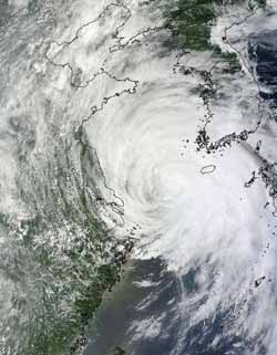
NASA's Aqua satellite captured this visible image of Tropical Storm Muifa moving through the Yellow Sea on Aug. 6 at 10:50 p.m. EDT. Muifa's edges were affecting China (left) and South Korea (top right). Credit: NASA Goddard MODIS Rapid Response<br>
Tropical Storm Muifa is filling up the Yellow Sea on NASA satellite imagery as it continues moving north today to a landfall in East China's Shandong province. NASA's Aqua satellite captured visible and infrared imagery that shows Muifa's cloud cover stretches across the Yellow Sea, from China to the west to South and North Korea to the east.
At 18:25 UTC 2:25 p.m. EDT, the Moderate Resolution Imaging Spectroradiometer (MODIS) instrument on NASA's Aqua satellite captured a visible image of Tropical Storm Muifa moving through the Yellow Sea on August 6 at10:50 p.m. EDT. Muifa's edges were affecting China and South Korea as it continues its northward track.
The Atmospheric Infrared Sounder (AIRS) instrument on NASA”s Aqua satellite saw strong thunderstorms around the eye of Muifa on August 6, 2011 at 1707 UTC 1:07 p.m. EDT. The largest area of the highest, coldest (colder than -63 Fahrenheit/-52 Celsius), cloud tops, where thunderstorms were the strongest and the heaviest rain was falling was east of the center.
AT 0900 UTC (5 a.m. EDT) on August 8, 2011, Tropical Storm Muifa's center was near 38.7 North and 124.0 East about 160 nautical miles west-northwest of Seoul, South Korea. Muifa had maximum sustained wind near 50 knots (57 mph/92 kmh). It was moving to the north near 12 knots (14 mph/22 kmh), north through the Yellow Sea. As Muifa continues to track through the Yellow Sea, it is generating very rough surf along coastal areas on both sides, including eastern China, South Korea and North Korea. Sea level heights have been estimated near 28 feet (8.5 meters).
Early on August 8, China.org reported that coastal areas of the city of Qingdao is being is already receiving high waves up to 16 feet (5 meters) high.
Muifa will make landfall in East China's Shandong province today.
Media Contact
More Information:
http://www.nasa.govAll latest news from the category: Earth Sciences
Earth Sciences (also referred to as Geosciences), which deals with basic issues surrounding our planet, plays a vital role in the area of energy and raw materials supply.
Earth Sciences comprises subjects such as geology, geography, geological informatics, paleontology, mineralogy, petrography, crystallography, geophysics, geodesy, glaciology, cartography, photogrammetry, meteorology and seismology, early-warning systems, earthquake research and polar research.


Newest articles

A universal framework for spatial biology
SpatialData is a freely accessible tool to unify and integrate data from different omics technologies accounting for spatial information, which can provide holistic insights into health and disease. Biological processes…

How complex biological processes arise
A $20 million grant from the U.S. National Science Foundation (NSF) will support the establishment and operation of the National Synthesis Center for Emergence in the Molecular and Cellular Sciences (NCEMS) at…

Airborne single-photon lidar system achieves high-resolution 3D imaging
Compact, low-power system opens doors for photon-efficient drone and satellite-based environmental monitoring and mapping. Researchers have developed a compact and lightweight single-photon airborne lidar system that can acquire high-resolution 3D…

