NASA satellite indicates Tropical Storm Prapiroon's rains mostly south of center
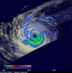
The TRMM satellite flew above Typhoon Prapiroon on Oct. 15, 2012 at 0632 UTC (2:32 a.m. EDT). Prapiroon's sustained wind speeds had dropped to 70 knots (~81 mph) with a large and ragged eye (black) being its dominant feature. TRMM's Microwave Imager (TMI) data indicated that the most intense rain bands south of Prapiroon's eye were dropping rain at a rate of about 30-40 mm/hour (~1.2 to 1.6 inches).<br><br>Credit: NASA/SSAI Hal Pierce<br>
NASA's Tropical Rainfall Measuring Mission (TRMM) satellite flew above Prapiroon when it was a typhoon on Oct. 15, 2012 at 0632 UTC (2:32 a.m. EDT). Prapiroon's sustained wind speeds had dropped to 70 knots (~81 mph) with a large and ragged eye being its dominant feature. TRMM's Microwave Imager (TMI) data indicated that the most intense rain bands south of Prapiroon's eye were dropping rain at a rate of about 30-40 mm/hour (~1.2 to 1.6 inches).
The erosion of the rainfall was still happening in satellite imagery on Oct. 16, and the bulk of the showers were occurring south of the center. Dry air has also been affecting the north side of the storm, and dry air absorbs the moisture that helps create the clouds and thunderstorms that make up the storm. The bands of showers and thunderstorms in the southern quadrant, however, are still strong.
On Oct. 16, 2012 at 1500 UTC, Tropical Storm Prapiroon, known as “Nina” in the Philippines, had maximum sustained winds near 60 knots (69 mph/111 kph). It was located near 22.2 North latitude and 129.3 East longitude, about 260 nautical miles (299 miles/481.5 km) south-southeast of Kadena Air Base, Okinawa, Japan. It was still moving slowly, just 5 knots (5.7 mph/9.2 kph) to the west. Prapiroon is still meandering until a mid-latitude shortwave trough (elongated area of low pressure) moving into central China can push it to the northeast.
Prapiroon is not expected to strengthen before it begins moving to the northeast on Oct. 17. The Joint Typhoon Warning Center forecasts the storm to become extra-tropical thereafter.
Media Contact
More Information:
http://www.nasa.govAll latest news from the category: Earth Sciences
Earth Sciences (also referred to as Geosciences), which deals with basic issues surrounding our planet, plays a vital role in the area of energy and raw materials supply.
Earth Sciences comprises subjects such as geology, geography, geological informatics, paleontology, mineralogy, petrography, crystallography, geophysics, geodesy, glaciology, cartography, photogrammetry, meteorology and seismology, early-warning systems, earthquake research and polar research.


Newest articles

A universal framework for spatial biology
SpatialData is a freely accessible tool to unify and integrate data from different omics technologies accounting for spatial information, which can provide holistic insights into health and disease. Biological processes…

How complex biological processes arise
A $20 million grant from the U.S. National Science Foundation (NSF) will support the establishment and operation of the National Synthesis Center for Emergence in the Molecular and Cellular Sciences (NCEMS) at…

Airborne single-photon lidar system achieves high-resolution 3D imaging
Compact, low-power system opens doors for photon-efficient drone and satellite-based environmental monitoring and mapping. Researchers have developed a compact and lightweight single-photon airborne lidar system that can acquire high-resolution 3D…

