NASA notes Nadine now no more
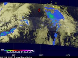
TRMM data on Oct. 3 at 10:49 p.m. EDT showed that Nadine was producing light to moderate rainfall (blue/green) in an area well east of the center of circulation, while the center (red symbol) was rain-free. The approaching cold front that would help bring about Nadine's demise was generating rainfall west of Nadine's center.<br><br>Credit: SSAI/NASA, Hal Pierce<br>
NASA's Tropical Rainfall Measuring Mission (TRMM) satellite passed above long-lasting Nadine for the last time before the tropical storm's dissipation on October 4, 2012 at 0249 UTC (10:49 p.m. EDT October 3, 2012).
TRMM measures rainfall from space and there was very little remaining in Nadine when it passed overhead. Rainfall data from TRMM's Microwave Imager (TMI) and Precipitation Radar (PR) showed that Nadine was producing light to moderate rainfall in an area well east of the center of circulation, while the center was rain-free.
TRMM data showed that the approaching cold front that would help bring about Nadine's demise was generating rainfall west of Nadine's center.
According to NOAA Hurricane Ginger lasted 28 days in the Atlantic Ocean in 1971. In the Pacific Ocean Hurricane John, renamed Typhoon John when it crossed the International Dateline holds the record with a 31 day lifetime during August and September 1994.
Although not the longest-lived tropical cyclone, Nadine is in the top 50 longest-lasting tropical cyclones in either ocean basin.
Media Contact
More Information:
http://www.nasa.govAll latest news from the category: Earth Sciences
Earth Sciences (also referred to as Geosciences), which deals with basic issues surrounding our planet, plays a vital role in the area of energy and raw materials supply.
Earth Sciences comprises subjects such as geology, geography, geological informatics, paleontology, mineralogy, petrography, crystallography, geophysics, geodesy, glaciology, cartography, photogrammetry, meteorology and seismology, early-warning systems, earthquake research and polar research.


Newest articles

A universal framework for spatial biology
SpatialData is a freely accessible tool to unify and integrate data from different omics technologies accounting for spatial information, which can provide holistic insights into health and disease. Biological processes…

How complex biological processes arise
A $20 million grant from the U.S. National Science Foundation (NSF) will support the establishment and operation of the National Synthesis Center for Emergence in the Molecular and Cellular Sciences (NCEMS) at…

Airborne single-photon lidar system achieves high-resolution 3D imaging
Compact, low-power system opens doors for photon-efficient drone and satellite-based environmental monitoring and mapping. Researchers have developed a compact and lightweight single-photon airborne lidar system that can acquire high-resolution 3D…

