NASA-NOAA Suomi NPP satellite sees power within newborn Tropical Depression 09W
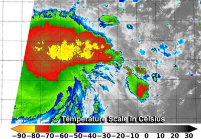
This infrared image from the VIIRS instrument aboard NASA-NOAA's Suomi NPP satellite taken July 10 at 14:48 UTC showed very cold cloud top temperatures in newborn Tropical Depression 09W. Credit: NASA/NOAA
Because TD09W is close to land areas, watches are already in effect. On July 10, a tropical storm watch is in force for Guam, Rota, Tinian and Saipan.
Tropical depression 09W was formerly known as low pressure System 92W. VIIRS instrument aboard NASA-NOAA's Suomi NPP satellite taken July 10 at 14:48 UTC showed cold cloud top temperatures in newborn Tropical Depression 09W.
An infrared image from the Visible Infrared Imaging Radiometer Suite (VIIRS) instrument aboard NASA-NOAA's Suomi NPP satellite taken July 10 at 14:48 UTC (10:48 a.m. EDT) showed cold cloud top temperatures in newborn Tropical Depression 09W.
VIIRS saw extremely cold cloud top temperatures near -80C (-112F). Temperatures that cold in Tropical Depression 09W are indicative of thunderstorms reaching high in the troposphere, and they are capable of producing heavy rain.
VIIRS collects visible and infrared imagery and global observations of land, atmosphere, cryosphere and oceans. VIIRS flies aboard the Suomi NPP satellite, which is managed by both NASA and NOAA.
At 1500 UTC (10 a.m. EDT) on July 10, Tropical Depression 09W had maximum sustained winds near 25 knots. It was located near 10.8 north latitude and 150.5 east longitude, about 372 nautical miles east-southeast of Andersen Air Force Base, Guam. TD09W was moving to the northwest at 15 knots.
The Joint Typhoon Warning Center expects TD09W to move past the southern islands of the Marianas and gradually strengthen into a typhoon.
Media Contact
More Information:
http://www.nasa.govAll latest news from the category: Earth Sciences
Earth Sciences (also referred to as Geosciences), which deals with basic issues surrounding our planet, plays a vital role in the area of energy and raw materials supply.
Earth Sciences comprises subjects such as geology, geography, geological informatics, paleontology, mineralogy, petrography, crystallography, geophysics, geodesy, glaciology, cartography, photogrammetry, meteorology and seismology, early-warning systems, earthquake research and polar research.


Newest articles

A universal framework for spatial biology
SpatialData is a freely accessible tool to unify and integrate data from different omics technologies accounting for spatial information, which can provide holistic insights into health and disease. Biological processes…

How complex biological processes arise
A $20 million grant from the U.S. National Science Foundation (NSF) will support the establishment and operation of the National Synthesis Center for Emergence in the Molecular and Cellular Sciences (NCEMS) at…

Airborne single-photon lidar system achieves high-resolution 3D imaging
Compact, low-power system opens doors for photon-efficient drone and satellite-based environmental monitoring and mapping. Researchers have developed a compact and lightweight single-photon airborne lidar system that can acquire high-resolution 3D…

