NASA infrared satellite data see an intensifying Tropical Storm Dianne
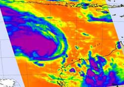
This NASA AIRS infrared image of Tropical Storm Dianne from Feb. 17 at 06:05 UTC (1:05 a.m. EST) shows a large area of strong convection and powerful thunderstorms (purple). Those cloud top temperatures in the strongest thunderstorms were as cold as or colder than -63F/-52C. Credit: NASA JPL, Ed Olsen<br>
NASA's Atmospheric Infrared Sounder (AIRS) infrared imagery suggests that Dianne's center of circulation is consolidating and getting organized. There are bands of thunderstorms wrapping into the center of the storm, indicating strengthening is occurring.
The AIRS instrument flies aboard NASA's Aqua satellite. The AIRS infrared image of Tropical Storm Dianne from Feb. 17 at 06:05 UTC (1:05 a.m. EST) showed a large area of strong convection and powerful thunderstorms. Those cloud top temperatures in the strongest thunderstorms were as cold as or colder than -63F/-52C.
Microwave imagery from the Advanced Microwave Sounding Unit (AMSU), a multi-channel microwave radiometer installed on meteorological satellites, even indicated that an eye had formed in Dianne's center.
Tropical Storm Dianne is on a southerly track through the Southern Indian Ocean and is currently forecast to stay off shore and away from Western Australia.
At 1500 UTC (10 a.m. EST) Tropical Cyclone Dianne had maximum sustained winds near 55 knots (63 mph/101 kmh). Tropical storm-force winds extend about 60 miles from the center. Dianne was centered about 260 nautical miles (299 miles/281 km) northwest of Learmonth, Australia near 19.0 South and 110.7 East. It was creeping to the southeast at 1 knot (1 mph/2 kmh). Dianne continues to generate waves as high as 19 feet (~6 meters) in that area of the Southern Indian Ocean.
The Joint Typhoon Warning Center (JTWC) expects Dianne to stop meandering and start moving south on Feb. 18 while intensifying. The JWTC does expect that Dianne will remain well west of the Australian coast. However, there are warnings posted for Western Australia. A Cyclone Warning is currently in effect for coastal areas from Exmouth to Coral Bay and a Cyclone Watch is in effect for coastal areas from Onslow to Exmouth and Coral Bay to Overlander Roadhouse, including Carnarvon and Denham.
Media Contact
More Information:
http://www.nasa.govAll latest news from the category: Earth Sciences
Earth Sciences (also referred to as Geosciences), which deals with basic issues surrounding our planet, plays a vital role in the area of energy and raw materials supply.
Earth Sciences comprises subjects such as geology, geography, geological informatics, paleontology, mineralogy, petrography, crystallography, geophysics, geodesy, glaciology, cartography, photogrammetry, meteorology and seismology, early-warning systems, earthquake research and polar research.


Newest articles

Sea slugs inspire highly stretchable biomedical sensor
USC Viterbi School of Engineering researcher Hangbo Zhao presents findings on highly stretchable and customizable microneedles for application in fields including neuroscience, tissue engineering, and wearable bioelectronics. The revolution in…

Twisting and binding matter waves with photons in a cavity
Precisely measuring the energy states of individual atoms has been a historical challenge for physicists due to atomic recoil. When an atom interacts with a photon, the atom “recoils” in…

Nanotubes, nanoparticles, and antibodies detect tiny amounts of fentanyl
New sensor is six orders of magnitude more sensitive than the next best thing. A research team at Pitt led by Alexander Star, a chemistry professor in the Kenneth P. Dietrich…

