NASA infrared image sees a stronger Tropical Storm Daphne
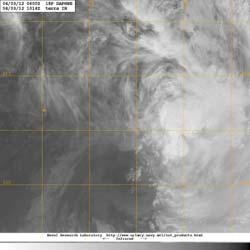
NASA's Terra satellite passed over Daphne at 1014 UTC (6:14 a.m. EDT or 10:14 p.m. local time, Auckland, New Zealand), and used infrared imagery from the Moderate Imaging Spectroradiometer (MODIS) instrument to visualize its cloud extent. The MODIS image showed Daphne to be more rounded and less elongated than it appeared in satellite imagery on April 2, indicating that wind shear had lessened. Credit: NASA/JTWC<br>
NASA's Terra satellite passed over Daphne at 1014 UTC (6:14 a.m. EDT or 10:14 p.m. local time, Auckland, New Zealand), and used infrared imagery from the Moderate Imaging Spectroradiometer (MODIS) instrument to visualize its cloud extent.
Like the infrared goggles used to see at night infrared satellite imagery can see cloud cover of tropical cyclones from space. The MODIS image showed Daphne to be more rounded and less elongated than it appeared in satellite imagery on April 2, indicating that wind shear had lessened. At that time, its minimum central pressure was 986 millibars.
On April 3 at 0300 UTC (April 2 at 11 a.m. EDT/3 p.m. local time, Auckland, New Zealand time), Tropical Storm Daphne had maximum sustained winds near 50 knots (57.5 mph/92.6 kph), up from 35 knots (40 mph/64 kph) on April 2. Daphne was located 744 nautical miles (856 miles/1378 km) east of Kingston Island, near 27.8 South and 178.0 West. Daphne was speeding to the southeast at 25 knots (28.7 mph/46.3 kph). As Daphne has moved, it has grown in size. Tropical-storm-force winds now extend as far as 300 nautical miles (345.2 miles/555.6 km) from the center, especially in the east and southern quadrants. Tropical-storm-force winds in the other quadrants appear to extend just further than 100 nautical miles (115 miles/185 km).
All warnings have been dropped for Fiji land areas, but mariners can expect rough seas between Fiji and New Zealand as Daphne continues moving southeast.
Forecasters at the Fleet Weather Center in Norfolk, Virginia are currently maintaining forecasts for tropical cyclones in the South Pacific. The current forecast takes Daphne on a south-southeasterly track over the next several days and keeps it away from New Zealand. Forecasters expect Daphne to begin weakening as it continues to move southeast as wind shear will increase and sea surface temperatures will drop.
Media Contact
More Information:
http://www.nasa.govAll latest news from the category: Earth Sciences
Earth Sciences (also referred to as Geosciences), which deals with basic issues surrounding our planet, plays a vital role in the area of energy and raw materials supply.
Earth Sciences comprises subjects such as geology, geography, geological informatics, paleontology, mineralogy, petrography, crystallography, geophysics, geodesy, glaciology, cartography, photogrammetry, meteorology and seismology, early-warning systems, earthquake research and polar research.


Newest articles

A universal framework for spatial biology
SpatialData is a freely accessible tool to unify and integrate data from different omics technologies accounting for spatial information, which can provide holistic insights into health and disease. Biological processes…

How complex biological processes arise
A $20 million grant from the U.S. National Science Foundation (NSF) will support the establishment and operation of the National Synthesis Center for Emergence in the Molecular and Cellular Sciences (NCEMS) at…

Airborne single-photon lidar system achieves high-resolution 3D imaging
Compact, low-power system opens doors for photon-efficient drone and satellite-based environmental monitoring and mapping. Researchers have developed a compact and lightweight single-photon airborne lidar system that can acquire high-resolution 3D…

