NASA Infrared Data Compares Super Typhoon Jelawat with Tropical Storm Ewiniar
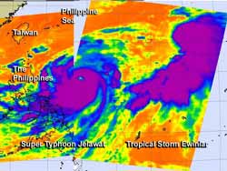
This combined image was created from infrared AIRS data of Super Typhoon Jelawat on Sept. 25 and Tropical Storm Ewiniar on Sept. 24 to give perspective of their distance from each other. The eye of Jelawat is clearly visible in the middle of powerful thunderstorms (purple) with very cold cloud top temperatures. Credit: NASA JPL/Ed Olsen<br>
A combined image created from infrared data obtained by the Atmospheric Infrared Sounder (AIRS) instrument that flies on NASA's Aqua satellite provides a comparison of the two monster storms in the western North Pacific Ocean basin.
An infrared image of Typhoon Jelawat captured on Sept. 25 was combined with an image of Tropical Storm Ewiniar, that was taken on Sept. 24. The combined image gives perspective of the distance of the tropical cyclones from each other. The image showed the close proximity of the storms. Earlier in the week, Jelawat's outflow was affecting Ewiniar and preventing it from strengthening more quickly.
The data also showed a visible eye in the center of super typhoon Jelawat in the middle of powerful thunderstorms with very cold cloud top temperatures that exceed -63 Fahrenheit (-52 Celsius). Jelawat also has a rounded shape indicating that circulation is strong and symmetrical. Tropical Storm Ewiniar, however, appears somewhat asymmetrical, in the form of an elongated comma shape. The comma's “tail” is a large band of strong thunderstorms wrapping into Ewiniar's center from the southeast.
The Moderate Resolution Imaging Spectroradiometer (MODIS) on NASA’s Aqua satellite captured a natural-color image on September 24, 2012, showing Jelawat just east of the Philippines. Sporting a distinct eye and spiral arms characteristic of strong storms, Jelawat spanned hundreds of kilometers (miles). As of September 24, 2012, the Joint Typhoon Warning Center (JTWC) classified Jelawat as a super typhoon. For the MODIS image, visit: http://lance-modis.eosdis.nasa.gov/cgi-bin/imagery/single.cgi?image=Jelawat.A2012268.0430.2km.jpg.
Jelawat remains a super typhoon today, Sept. 25, with maximum sustained winds near 140 knots (161 mph/259 kmh). It is located 385 nautical miles east-northeast of Manila, Philippines, and is moving north-northwestward at 6 knots (7 mph/11 kmh). Satellite imagery is showing tightly wrapped bands of thunderstorms spiraling into the eye of the storm. The eye is about 17 nautical miles wide. High pressure in the upper atmosphere and low wind shear are helping the super typhoon maintain its intensity. The JTWC projected storm track showed the storm moving toward the north-northwest over the next several days, passing near the island of Taiwan before turning toward the northeast.
Text credit: Rob Gutro
NASA's Goddard Space Flight Center, Greenbelt, Md.
Media Contact
All latest news from the category: Earth Sciences
Earth Sciences (also referred to as Geosciences), which deals with basic issues surrounding our planet, plays a vital role in the area of energy and raw materials supply.
Earth Sciences comprises subjects such as geology, geography, geological informatics, paleontology, mineralogy, petrography, crystallography, geophysics, geodesy, glaciology, cartography, photogrammetry, meteorology and seismology, early-warning systems, earthquake research and polar research.


Newest articles

A universal framework for spatial biology
SpatialData is a freely accessible tool to unify and integrate data from different omics technologies accounting for spatial information, which can provide holistic insights into health and disease. Biological processes…

How complex biological processes arise
A $20 million grant from the U.S. National Science Foundation (NSF) will support the establishment and operation of the National Synthesis Center for Emergence in the Molecular and Cellular Sciences (NCEMS) at…

Airborne single-photon lidar system achieves high-resolution 3D imaging
Compact, low-power system opens doors for photon-efficient drone and satellite-based environmental monitoring and mapping. Researchers have developed a compact and lightweight single-photon airborne lidar system that can acquire high-resolution 3D…

