NASA's TRMM satellite eyes rainfall in Tropical Cyclone Fobane
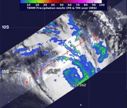
When TRMM passed over Tropical Cyclone Fobane on Feb. 10 at 0228 UTC/Feb. 9 at 9:28 p.m. EST, it spotted some thunderstorms up to 14 km/8.6 miles, where rainfall rates were near 35 mm/1.3 inches (green) near the center of circulation.<br><br>Credit: NASA/SSAI, Hal Pierce<br>
NASA and the Japan Aerospace Exploration Agency manages the Tropical Rainfall Measuring Mission satellite known as TRMM. TRMM has the capability to measure rainfall rates from space and data that can be used to determine the heights of thunderstorms that make up a storm.
When TRMM passed over Tropical Cyclone Fobane on February 10 at 0228 UTC/Feb. 9 at 9:28 p.m. EST, it spotted some thunderstorms up to 14 km/8.6 miles, where rainfall rates were near 35 mm/1.3 inches near the center of circulation.
On February 10 at 0900 UTC/4 a.m. EST, Tropical Cyclone Fobane, known on La Reunion island as Tropical Cyclone 11/20132014, was located near 22.5 south latitude and 72.6 east longitude, about 973 nautical miles/1,120 miles/1,802 km east of St, Denis, La Reunion. Fobane's maximum sustained winds were near 55 knots/63.2 mph/101.9 kph and the storm was weakening. It was moving to the southwest at 21 knots/24.1 mph/ 38.8 kph.
Fobane has moved into an area of moderate to strong vertical wind shear, according to the Joint Typhoon Warning Center. That wind shear is not expected to let up and Fobane is moving into cooler waters, so the storm is expected to continue to weaken.
Fobane is expected to continue moving in a southerly direction over open waters over the next several days as it passes far to the southeast of La Reunion Island.
Media Contact
More Information:
http://www.nasa.govAll latest news from the category: Earth Sciences
Earth Sciences (also referred to as Geosciences), which deals with basic issues surrounding our planet, plays a vital role in the area of energy and raw materials supply.
Earth Sciences comprises subjects such as geology, geography, geological informatics, paleontology, mineralogy, petrography, crystallography, geophysics, geodesy, glaciology, cartography, photogrammetry, meteorology and seismology, early-warning systems, earthquake research and polar research.


Newest articles

A universal framework for spatial biology
SpatialData is a freely accessible tool to unify and integrate data from different omics technologies accounting for spatial information, which can provide holistic insights into health and disease. Biological processes…

How complex biological processes arise
A $20 million grant from the U.S. National Science Foundation (NSF) will support the establishment and operation of the National Synthesis Center for Emergence in the Molecular and Cellular Sciences (NCEMS) at…

Airborne single-photon lidar system achieves high-resolution 3D imaging
Compact, low-power system opens doors for photon-efficient drone and satellite-based environmental monitoring and mapping. Researchers have developed a compact and lightweight single-photon airborne lidar system that can acquire high-resolution 3D…

