Microwave satellite imagery shows an eye developing in Mirinae
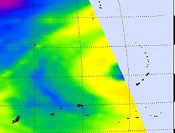
This NASA AIRS microwave image of Mirinae from Oct. 27 shows the development of an eye (purple area resembling a half moon). Cold areas (yellow-green) indicate precipitation or ice in the cloud tops. The purple area has the coldest cloud temperatures (as cold as -63F), and suggest cloud tops are near the tropopause. Credit: NASA JPL, Ed Olsen <br>
Tropical Storm Mirinae had maximum sustained winds near 52 mph on Tuesday, October 27 at 1200 UTC (8 a.m. EDT). It was located about 205 nautical miles northwest of Guam, so all of the watches and warnings for Guam have been discontinued. Its center is near 15.6 North latitude and 142.2 East longitude. Mirinae was moving west-northwest near 19 mph.
The U.S. Navy's Joint Typhoon Warning Center (JWTC) is the organization that forecasts tropical cyclones in the Western Pacific Ocean. Today's JWTC discussion noted that microwave satellite imagery has shown that the storm is developing an eye, and that's “typical of systems 45 Knots (52 mph) or greater.”
NASA's Aqua satellite flew over Tropical Storm Mirinae on October 27 at 0423 UTC. (12:23 a.m. EDT or 12:23 p.m. local Asia/Manila Time). Both infrared and microwave images were created from the Atmospheric Infrared Sounder (AIRS) instrument, and both showed some high, powerful thunderstorms and a developing eye, two signs that the storm was intensifying. A microwave image was created combining AIRS and Advanced Microwave Sounding Unit (AMSU) data. AMSU is another instrument that flies on NASA's Aqua satellite.
The microwave image revealed cold areas in the storm that indicate ice in cloud tops, and heavy precipitation. Because winds are strongest around the eye, that's where you would also likely find the most powerful thunderstorms and rotation, so it makes sense that around the developing eye are the coldest cloud temperatures, as cold as -63F. Microwave data suggests cloud heights to the 200 millibar level, near the tropopause.
Tropical Storm Mirinae continues to move west-northwest, away from the Northern Marianas and toward the Philippines. The storm is forecast to strengthen on its westward track, so residents in the Philippines need to prepare for its arrival toward the end of the week.
Media Contact
More Information:
http://www.nasa.govAll latest news from the category: Earth Sciences
Earth Sciences (also referred to as Geosciences), which deals with basic issues surrounding our planet, plays a vital role in the area of energy and raw materials supply.
Earth Sciences comprises subjects such as geology, geography, geological informatics, paleontology, mineralogy, petrography, crystallography, geophysics, geodesy, glaciology, cartography, photogrammetry, meteorology and seismology, early-warning systems, earthquake research and polar research.


Newest articles

A universal framework for spatial biology
SpatialData is a freely accessible tool to unify and integrate data from different omics technologies accounting for spatial information, which can provide holistic insights into health and disease. Biological processes…

How complex biological processes arise
A $20 million grant from the U.S. National Science Foundation (NSF) will support the establishment and operation of the National Synthesis Center for Emergence in the Molecular and Cellular Sciences (NCEMS) at…

Airborne single-photon lidar system achieves high-resolution 3D imaging
Compact, low-power system opens doors for photon-efficient drone and satellite-based environmental monitoring and mapping. Researchers have developed a compact and lightweight single-photon airborne lidar system that can acquire high-resolution 3D…

