Haiyan and Tropical Storm 30W Bring Heavy Rains to the Phillipines
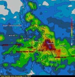
The combined rainfall from these tropical cyclones is shown in this image during the period from November 2-12, 2013. <br>Image Credit: Hal Pierce, SSAI/NASA GSFC<br>
So far, over 2300 people are confirmed to have been killed by the storm, and the number is likely to climb higher with many still missing and not all areas unaccounted for. Katrina, which devasted the US Gulf coast in 2005, was responsible for 1833 fatalities.
The most deadly flooding from Super Typhoon Haiyan was caused by the storm surge, which was reported to be up to 5.2 meters (~17 feet) in Tacloban, located on the northeast tip of Leyte, where the strong cyclonic winds from Haiyan funneled water into the northwest corner of Leyte Gulf between the islands of Leyte and Samar.
In addition to the fierce winds and powerful surge, Haiyan brought copious amounts of rainfall to the central Philippines along with Tropical Storm Thirty and another tropical disturbance (90w), which all passed through the the central Philippines within in the past ten days.
The combined rainfall from these tropical cyclones (first image to the right) in the TRMM-based, near-real time Multi-satellite Precipitation data (TMPA) analysis shown above during the period from November 2-12, 2013.
It shows that most of the island of Leyte had rainfall totals greater than 500mm (~19.7 inches, dark red) with a peak amount of over 685 mm (~27 inches, lighter purple) located over the southeast corner of the island.
Peak and average rainfall over the central Philippines (second image to the right) shows that despite being far less intense, Tropical Storm Thirty, which preceded Super Typhoon Haiyan by about three days, produced similar peak rain intensities (shown in red) and over a similar duration, but less average rainfall (shown in blue) than Haiyan.
TRMM is a joint mission between NASA and the Japanese space agency JAXA.
Text credit: Hal Pierce/Steve Lang SSAI/NASA GSFC
NASA's Goddard Space Flight Center
Media Contact
All latest news from the category: Earth Sciences
Earth Sciences (also referred to as Geosciences), which deals with basic issues surrounding our planet, plays a vital role in the area of energy and raw materials supply.
Earth Sciences comprises subjects such as geology, geography, geological informatics, paleontology, mineralogy, petrography, crystallography, geophysics, geodesy, glaciology, cartography, photogrammetry, meteorology and seismology, early-warning systems, earthquake research and polar research.


Newest articles

A universal framework for spatial biology
SpatialData is a freely accessible tool to unify and integrate data from different omics technologies accounting for spatial information, which can provide holistic insights into health and disease. Biological processes…

How complex biological processes arise
A $20 million grant from the U.S. National Science Foundation (NSF) will support the establishment and operation of the National Synthesis Center for Emergence in the Molecular and Cellular Sciences (NCEMS) at…

Airborne single-photon lidar system achieves high-resolution 3D imaging
Compact, low-power system opens doors for photon-efficient drone and satellite-based environmental monitoring and mapping. Researchers have developed a compact and lightweight single-photon airborne lidar system that can acquire high-resolution 3D…

