Fires in the Northern Territories July 2014
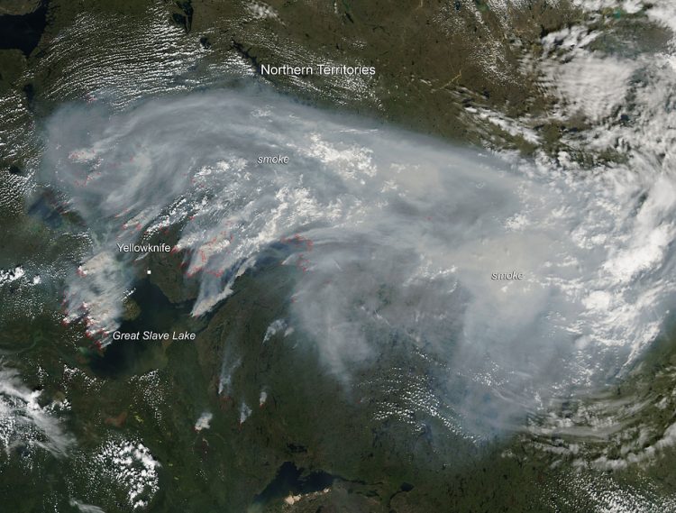
In the image taken by the Aqua satellite, the smoke is drifting eastward along normal wind patterns. Fire is an obvious health hazard, but the smoke that comes from fires is not quite so obvious and its effects are insidious.
The smoke released by any type of fire (forest, brush, crop, structure, tires, waste or wood burning) is a mixture of particles and chemicals produced by incomplete burning of carbon-containing materials.
All smoke contains carbon monoxide, carbon dioxide and particulate matter (PM or soot). Smoke can contain many different chemicals, including aldehydes, acid gases, sulfur dioxide, nitrogen oxides, polycyclic aromatic hydrocarbons (PAHs), benzene, toluene, styrene, metals and dioxins.
The type and amount of particles and chemicals in smoke varies depending on what is burning, how much oxygen is available, and the burn temperature.
Exposure to high levels of smoke should be avoided. Individuals are advised to limit their physical exertion if exposure to high levels of smoke cannot be avoided. Individuals with cardiovascular or respiratory conditions (e.g., asthma), fetuses, infants, young children, and the elderly may be more vulnerable to the health effects of smoke exposure.
High values are forecast to persist until this evening (7/23) when a cold front moves across the region and is expected to clear some of the smoke.
There are currently 160 fires burning throughout the Northwest Territories.
This natural-color satellite image was collected by the Moderate Resolution Imaging Spectroradiometer (MODIS) aboard the Aqua satellite on July 22, 2014. Actively burning areas, detected by MODIS’s thermal bands, are outlined in red. NASA image courtesy Jeff Schmaltz, MODIS Rapid Response Team. Caption: NASA/Goddard, Lynn Jenner with information from North American Fire Incident Display system.
Media Contact
All latest news from the category: Earth Sciences
Earth Sciences (also referred to as Geosciences), which deals with basic issues surrounding our planet, plays a vital role in the area of energy and raw materials supply.
Earth Sciences comprises subjects such as geology, geography, geological informatics, paleontology, mineralogy, petrography, crystallography, geophysics, geodesy, glaciology, cartography, photogrammetry, meteorology and seismology, early-warning systems, earthquake research and polar research.


Newest articles

A universal framework for spatial biology
SpatialData is a freely accessible tool to unify and integrate data from different omics technologies accounting for spatial information, which can provide holistic insights into health and disease. Biological processes…

How complex biological processes arise
A $20 million grant from the U.S. National Science Foundation (NSF) will support the establishment and operation of the National Synthesis Center for Emergence in the Molecular and Cellular Sciences (NCEMS) at…

Airborne single-photon lidar system achieves high-resolution 3D imaging
Compact, low-power system opens doors for photon-efficient drone and satellite-based environmental monitoring and mapping. Researchers have developed a compact and lightweight single-photon airborne lidar system that can acquire high-resolution 3D…

