Second Atlantic season tropical depression forms
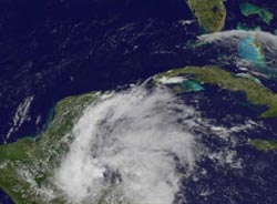
Tropical Depression 2 formed in the western Caribbean Sea during the early afternoon hours (Eastern Daylight Time) on June 17. NOAA's GOES-13 satellite captured an image of the storm as it consolidated enough to become a tropical depression while approaching the coast of Belize.<br><br>Credit: NASA GOES Project/NASA's Goddard Space Flight Center<br>
NOAA's GOES-13 satellite sits in a fixed orbit and monitors the weather in the eastern half of the continental United States and the Atlantic Ocean. NASA's GOES Project at NASA's Goddard Space Flight Center in Greenbelt, Maryland uses the data from GOES-13 and creates imagery. NASA's GOES Project created an image of Tropical Depression 2 from June 17 at 1:10 p.m. EDT.
Looking closely at the imagery, strong thunderstorms are firing up around the center of circulation, just off-shore from Belize. The clouds associated with the depression stretch much farther, from far western Cuba, to the eastern Yucatan Peninsula, and over Belize and Honduras.
The National Hurricane Center designated the low pressure area as Tropical Depression 2 at 11 a.m. EDT. At that time it had maximum sustained winds near 35 mph (55 kph) and was moving to the west-northwest at 13 mph (20 kph). Tropical Depression 2 is located near 16.2 north and 87.6 west, about 60 miles (95 km) east of Monkey River Town, Belize.
The center of the depression will move inland over southern Belize this afternoon where no change in strength is expected as it moves over land. The depression could emerge into the Bay of Campeche on Tuesday, according to the National Hurricane Center (NHC). NHC noted that an increase in strength is possible on Tuesday if the center emerges into the Bay of Campeche. If that happens, Tropical Depression 2 could become Tropical Storm Barry.
Media Contact
More Information:
http://www.nasa.govAll latest news from the category: Earth Sciences
Earth Sciences (also referred to as Geosciences), which deals with basic issues surrounding our planet, plays a vital role in the area of energy and raw materials supply.
Earth Sciences comprises subjects such as geology, geography, geological informatics, paleontology, mineralogy, petrography, crystallography, geophysics, geodesy, glaciology, cartography, photogrammetry, meteorology and seismology, early-warning systems, earthquake research and polar research.


Newest articles

A universal framework for spatial biology
SpatialData is a freely accessible tool to unify and integrate data from different omics technologies accounting for spatial information, which can provide holistic insights into health and disease. Biological processes…

How complex biological processes arise
A $20 million grant from the U.S. National Science Foundation (NSF) will support the establishment and operation of the National Synthesis Center for Emergence in the Molecular and Cellular Sciences (NCEMS) at…

Airborne single-photon lidar system achieves high-resolution 3D imaging
Compact, low-power system opens doors for photon-efficient drone and satellite-based environmental monitoring and mapping. Researchers have developed a compact and lightweight single-photon airborne lidar system that can acquire high-resolution 3D…

