2 NASA satellites see a newborn tropical storm near Madagascar
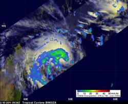
NASA and JAXA\'s TRMM satellite captured the rainfall rates of Tropical Storm Bingiza on Feb. 10 at 06:39 UTC (1:39 a.m. EST). The rainfall appears to be around the entire storm with the exception of the south and southeastern quadrants. The yellow and green areas indicate moderate rainfall between .78 to 1.57 inches per hour. Red areas are heavy rainfall at almost 2 inches per hour. Credit: NASA/SSAI, Hal Pierce<br>
The Moderate Resolution Imaging Spectroradiometer (MODIS) instrument aboard NASA's Terra satellite captured this image of Tropical Storm Bingiza at 06:30 UTC (1:30 a.m. EST) on its approach to Madagascar. The highest, strongest thunderstorms appeared almost bubble-like near the center of the storm's circulation.
The Tropical Rainfall Measuring Mission (TRMM) Satellite also flew over the storm and using microwave data and precipitation radar measured the rainfall rates happening throughout the storm.
TRMM captured the rainfall rates of Tropical Storm Bingiza on Feb. 10 at 06:39 UTC (1:39 a.m. EST). A precipitation analysis from TRMM's Microwave Imager (TMI) and Precipitation Radar (PR) data shows that the intensifying storm had a fairly large area of moderate rainfall, falling at a rate between .78 to 1.57 inches (20 to 40 mm) per hour. The rainfall appeared to be around the entire storm with the exception of the south and southeastern quadrants.
Multispectral satellite imagery shows that the low-level circulation center is well-defined. There is also strong convection wrapping around the northern edge of the center, which is where TRMM saw most of the rainfall occurring.
At 0900 UTC (4 a.m. EST) on Feb. 10, Tropical Storm Bingiza had maximum sustained winds near 45 knots (52 mph/83 kmh). It was about 460 miles (740 km) north of La Reunion, near 13.6 South and 54.4 East. It was creeping slowing to the northwest near 1 knot (1 mph/2 kmh).
Tropical Storm Bingiza is intensifying slowly and is expected to meander slowly over the next couple of days. Over the weekend, Bingiza is expected to move southwest once a sub-tropical ridge (elongated area) of high pressure builds in. It is also forecast to strengthen and move toward central Madagascar. Currently a landfall is not expected until early next week in central Madagascar.
Media Contact
More Information:
http://www.nasa.govAll latest news from the category: Earth Sciences
Earth Sciences (also referred to as Geosciences), which deals with basic issues surrounding our planet, plays a vital role in the area of energy and raw materials supply.
Earth Sciences comprises subjects such as geology, geography, geological informatics, paleontology, mineralogy, petrography, crystallography, geophysics, geodesy, glaciology, cartography, photogrammetry, meteorology and seismology, early-warning systems, earthquake research and polar research.


Newest articles

A universal framework for spatial biology
SpatialData is a freely accessible tool to unify and integrate data from different omics technologies accounting for spatial information, which can provide holistic insights into health and disease. Biological processes…

How complex biological processes arise
A $20 million grant from the U.S. National Science Foundation (NSF) will support the establishment and operation of the National Synthesis Center for Emergence in the Molecular and Cellular Sciences (NCEMS) at…

Airborne single-photon lidar system achieves high-resolution 3D imaging
Compact, low-power system opens doors for photon-efficient drone and satellite-based environmental monitoring and mapping. Researchers have developed a compact and lightweight single-photon airborne lidar system that can acquire high-resolution 3D…

