HS3 Mission Identifies Area of Strong Winds, Rain in Hurricane Ingrid
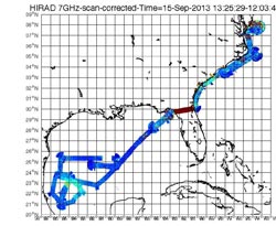
Data from the real-time HIRAD data stream from the Hurricane Ingrid flight on Sept. 15. The greenish-blue and yellow area near Mexico suggests rain and strong winds in Hurricane Ingrid. The dark red across north Florida is because land appears much warmer than ocean at microwave frequencies.<br>Image Credit: NASA<br>
HIRAD identified an area of heavy rains and and likely strong winds in Hurricane Ingrid by measuring surface wind speeds and rain rates using its rectangular antenna to track activity on the ocean’s surface.
NASA's Global Hawk 871 is the over-storm Global Hawk that carried HIRAD on a flight over Hurricane Ingrid on Sept. 15 as the storm moved through the extreme southwestern Gulf of Mexico and traveled west-northwestward along Mexico's east coast.
Along with HIRAD, Global Hawk 871 also carried the High-altitude Imaging Wind and Rain Airborne Profiler or HIWRAP, the High-Altitude Monolithic Microwave Integrated Circuit Sounding Radiometer or HAMSR and the Airborne Detector for Energetic Lightning Emission or ADELE instrument.
Late on Sept. 14, Ingrid had strengthened into a hurricane. At 11 a.m. EDT on Sept. 15 the center of Hurricane Ingrid was located near latitude 22.56 north and longitude 95.8 west, about 135 miles/220 km east of Tampico, Mexico. Ingrid was moving toward the west-northwest at 6 mph/ 11 kph. Maximum sustained winds were near 75 mph/ 120 kph.
On Sept. 15, the HIRAD instrument scanned Hurricane Ingrid from its perch on NASA Global Hawk 871. “HIRAD data definitely saw most of the strong wind and heavy rain on the northern and eastern sides of Hurricane Ingrid in the area generally near 23 degrees north latitude and 95 degrees west longitude,” said Daniel J. Cecil, the Principal Investigator for the HIRAD instrument at NASA's Marshall Space Flight Center in Huntsville, Ala.
HIRAD data provides “brightness temperature data” that is color-coded by Cecil and his team to indicate areas of falling rain and possible moderate-to-strong surface winds.
The antenna on HIRAD makes measurements of microwaves emitted by the ocean surface that are increased by the storm. As winds move across the surface of the sea they generate white, frothy foam. This sea foam causes the ocean surface to emit increasingly large amounts of microwave radiation, similar in frequency or wavelength, but much lower intensity, to that generated within a typical home microwave oven. HIRAD measures that microwave energy and, in doing so, allows scientists to deduce how powerfully the wind is blowing. With HIRAD’s unique capabilities, the two-dimensional structure of the surface wind field can be much more accurately determined than current operational capabilities allow. HIRAD was developed at the Marshall Space Flight Center, Huntsville, Ala.
TRMM image of Ingrid
NASA's Tropical Rainfall Measuring Mission or TRMM satellite measured rainfall in Hurricane Ingrid on Sept. 15 at 10:27 p.m. EDT and found some heavy rainfall (red) around its center. Mexican states are labeled on this image.
Image Credit: SSAI/NASA
Image Token:
Later that night, NASA's Tropical Rainfall Measuring Mission or TRMM satellite passed over Hurricane Ingrid at 10:27 p.m. EDT and confirmed some heavy rainfall north and east of its center. In those areas, rain was falling at a rate of 2 inches/50 mm per hour. Hurricane Ingrid made landfall in La Pesca located in northeastern Mexico on Monday, Sept. 16.
There is a difference between the HIRAD and TRMM data. “HIRAD uses lower frequencies than TRMM, and measures surface wind speed in addition to rain rate,” said Cecil. HIRAD gives a higher resolution rain mapping. “By being on an airplane, HIRAD can fly across a storm several times with the exact track being chosen; a satellite like TRMM will only cross the storm occasionally and its track cannot be adjusted.”
There are a couple of other differences between TRMM and HIRAD data. TRMM covers a much larger viewing area than HIRAD and TRMM provides information about vertical cross-sections of storms in addition to horizontal maps. TRMM has been observing storms since 1997 from its orbit around the Earth and HIRAD gathers data from an airplane within ~24 hour long flights.
For more information about the storm history and how NASA satellites captured it, visit Ingrid's story history on the NASA Hurricane page: http://www.nasa.gov/content/goddard/ingrid-atlanticgulf-of-mexico/
For more information about NASA's HS3 Mission, visit: www.nasa.gov/HS3
Rob Gutro
NASA's Goddard Space Flight Center
Media Contact
All latest news from the category: Earth Sciences
Earth Sciences (also referred to as Geosciences), which deals with basic issues surrounding our planet, plays a vital role in the area of energy and raw materials supply.
Earth Sciences comprises subjects such as geology, geography, geological informatics, paleontology, mineralogy, petrography, crystallography, geophysics, geodesy, glaciology, cartography, photogrammetry, meteorology and seismology, early-warning systems, earthquake research and polar research.


Newest articles

A universal framework for spatial biology
SpatialData is a freely accessible tool to unify and integrate data from different omics technologies accounting for spatial information, which can provide holistic insights into health and disease. Biological processes…

How complex biological processes arise
A $20 million grant from the U.S. National Science Foundation (NSF) will support the establishment and operation of the National Synthesis Center for Emergence in the Molecular and Cellular Sciences (NCEMS) at…

Airborne single-photon lidar system achieves high-resolution 3D imaging
Compact, low-power system opens doors for photon-efficient drone and satellite-based environmental monitoring and mapping. Researchers have developed a compact and lightweight single-photon airborne lidar system that can acquire high-resolution 3D…

