Kamchatka volcano blows its top
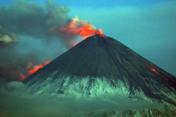
This photo captures strombolian activity and lava flows of Klyuchevskoy volcano on May 31, 2007. Credit: Photo by Yu Demyanchuk
Klyuchevskoy (pronounced Kloo-shef-skoy), a stratovolcano located in the north central region of the Kamchatka Peninsula, is blasting ash up to 32,000 feet in the air, and has diverted air traffic headed toward the Far East. This is the largest eruption to occur in the North Pacific in a decade, and is providing students at the University of Alaska Fairbanks a unique opportunity to collaborate with scientists, as well as state and federal agencies.
Tracking the Klyuchevskoy eruption locally are a handful students and faculty from the Geophysical Institute and the Alaska Volcano Observatory (GI/AVO) who process data used to reroute air traffic around dangerous volcanic ash clouds. Information is collected by satellite, Web cam, and Puff, a three-dimensional volcanic ash computer model. Once these data are synthesized, they are then shared at large to ensure the safety of thousands of people living in, or flying through the North Pacific.
Klyuchevskoy’s been erupting since January, but the largest explosions in the eruption began June 28, 2007. These explosions created a 1,360-mile-long band of ash, stretching from the Sea of Okhotsk to the Aleutian Islands, clogging well-used air routes with volcanic ash that prove deadly for aircraft.
“It’s best for us to keep an eye on Klyuchevskoy,” said Ken Dean, a professor of geology specializing in remote sensing with the Geophysical Institute and the Alaska Volcano Observatory. “Any ash that travels to Alaska is drifting right through the superhighway of air travel to the Far East. It’s critical for us to understand how distal plumes are moving.”
The eruption of one volcano will have far-reaching affects. Although Klyuchevskoy is located in Kamchatka, its ash crossed the Bering Sea and reached Unimak Island in the Aleutians within one day. Volcanic ash moves quickly through the atmosphere, so it’s important for scientists to have up-to-date information at their fingertips to generate a response plan.
Twice a day, the GI/AVO team goes through a rigorous process to examine the current condition of the more than 150 active volcanoes in the North Pacific. In addition, faculty is on call 24-hours a day to respond to large events like the recent explosions from Klyuchevskoy to guarantee information is shared and public safety is addressed.
Media Contact
All latest news from the category: Earth Sciences
Earth Sciences (also referred to as Geosciences), which deals with basic issues surrounding our planet, plays a vital role in the area of energy and raw materials supply.
Earth Sciences comprises subjects such as geology, geography, geological informatics, paleontology, mineralogy, petrography, crystallography, geophysics, geodesy, glaciology, cartography, photogrammetry, meteorology and seismology, early-warning systems, earthquake research and polar research.


Newest articles

Sea slugs inspire highly stretchable biomedical sensor
USC Viterbi School of Engineering researcher Hangbo Zhao presents findings on highly stretchable and customizable microneedles for application in fields including neuroscience, tissue engineering, and wearable bioelectronics. The revolution in…

Twisting and binding matter waves with photons in a cavity
Precisely measuring the energy states of individual atoms has been a historical challenge for physicists due to atomic recoil. When an atom interacts with a photon, the atom “recoils” in…

Nanotubes, nanoparticles, and antibodies detect tiny amounts of fentanyl
New sensor is six orders of magnitude more sensitive than the next best thing. A research team at Pitt led by Alexander Star, a chemistry professor in the Kenneth P. Dietrich…

