South Dakota geologic map receives 50-year facelift
South Dakota’s geology hasn’t changed much during the past few thousand years, but our knowledge of it has grown so much since 1953 that a new geological map of the entire state became necessary.
“The map is multidimensional in its use,” Dr. James Martin said. Martin is the South Dakota School of Mines and Technology’s curator of vertebrate paleontology and a professor in the engineering and science university’s Department of Geology and Geological Engineering. Martin led the effort to complete the update. “It can be consulted for such interests as mining, water resources, geological hazards, petroleum, agriculture, planning and others. It is the only source that includes the geology of the entire state in one place.”
The investigators updated the map by researching all known geological sources and publications, mapping of selected areas, and compiling the data.
The South Dakota Geological Survey funded the project. Researchers and scientists from Tech have been involved with the project from the beginning to serve the state’s business and social interests to generate and make use of new geological information.
The update began approximately 20 years ago and was primarily completed by Martin, J. Foster Sawyer, South Dakota Geological Survey, and Mark D. Fahrenbach, also of the South Dakota Geological Survey. Derric Iles, South Dakota State Geologist, also provided critical support and direction, particularly near the end of this large effort.
Others involved in the project included Dr. Arden Davis, Dr. Jack Redden, Dr. Alvis Lisenbee, and Dr. Jim Fox, all from Tech’s Department of Geology and Geological Engineering.
Media Contact
More Information:
http://www.sdsmt.eduAll latest news from the category: Earth Sciences
Earth Sciences (also referred to as Geosciences), which deals with basic issues surrounding our planet, plays a vital role in the area of energy and raw materials supply.
Earth Sciences comprises subjects such as geology, geography, geological informatics, paleontology, mineralogy, petrography, crystallography, geophysics, geodesy, glaciology, cartography, photogrammetry, meteorology and seismology, early-warning systems, earthquake research and polar research.


Newest articles
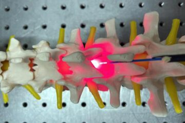
Red light therapy for repairing spinal cord injury passes milestone
Patients with spinal cord injury (SCI) could benefit from a future treatment to repair nerve connections using red and near-infrared light. The method, invented by scientists at the University of…
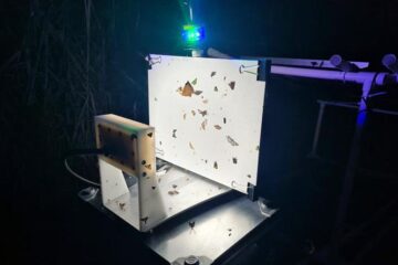
Insect research is revolutionized by technology
New technologies can revolutionise insect research and environmental monitoring. By using DNA, images, sounds and flight patterns analysed by AI, it’s possible to gain new insights into the world of…
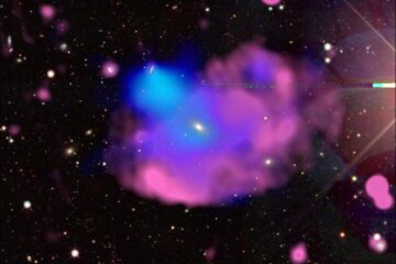
X-ray satellite XMM-newton sees ‘space clover’ in a new light
Astronomers have discovered enormous circular radio features of unknown origin around some galaxies. Now, new observations of one dubbed the Cloverleaf suggest it was created by clashing groups of galaxies….

