NASA Sees Tropical Storm Yagi Spinning in Western Pacific Ocean
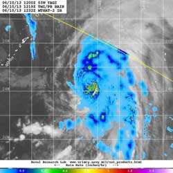
NASA’s TRMM satellite captured the rate rain was falling within Tropical Storm Yagi on June 10 at 8:19 a.m. EDT. The heaviest rain was falling around the center of circulation at as much as 1.2 inches per hour. TRMM data was overlaid on infrared cloud imagery from the MTSAT-2 satellite. Credit: NASA/NRL<br>
NASA and the Japanese Space Agency’s Tropical Rainfall Measuring Mission or TRMM satellite captured the rate rain was falling within Tropical Storm Yagi on June 10 at 8:19 a.m. EDT. The heaviest rain was falling south of the center around the center of circulation at as much as 1.2 inches (30.4 mm) per hour.
On June 10, 2013 at 1500 UTC (11 a.m. EDT), Tropical Storm Yagi had maximum sustained winds near 45 knots (51.7 mph/83.3 kph), which is expected to be its peak wind speed. Yagi was located near 25.0 north and 135.2 east, about 344 nautical miles (396 miles/ 637.1 km) west of Iwo Jima, Japan. Yagi is moving to the northeast at 12 knots (13.8 mph/22.2 kph).
According to the Joint Typhoon Warning Center, animated infrared imagery reveals a tightly wrapped low-level circulation center that is surrounded by shallow convection. Strong convection (rising air that forms thunderstorms) appears limited in the tropical storm.
To the north of Yagi, vertical wind shear is moderate (between 15 and 20 knots/17.2 and 23.0/ 27.7 and 37.0 kph), and wind shear inhibits development of thunderstorms. Wind shear is a measure of how the speed and direction of winds change with altitude. Water vapor imagery shows that there is sinking air (subsidence) along the western edge of the storm, which is also inhibiting the development of thunderstorms.
Sea surface temperatures remain warm enough to support Yagi, so the storm is expected to maintain strength for the next 24 hours as it moves northeast. Yagi is expected to dissipate south of Japan sometime before June 14.
Text credit: Rob Gutro
NASA’s Goddard Space Flight Center
Media Contact
All latest news from the category: Earth Sciences
Earth Sciences (also referred to as Geosciences), which deals with basic issues surrounding our planet, plays a vital role in the area of energy and raw materials supply.
Earth Sciences comprises subjects such as geology, geography, geological informatics, paleontology, mineralogy, petrography, crystallography, geophysics, geodesy, glaciology, cartography, photogrammetry, meteorology and seismology, early-warning systems, earthquake research and polar research.


Newest articles

Sea slugs inspire highly stretchable biomedical sensor
USC Viterbi School of Engineering researcher Hangbo Zhao presents findings on highly stretchable and customizable microneedles for application in fields including neuroscience, tissue engineering, and wearable bioelectronics. The revolution in…

Twisting and binding matter waves with photons in a cavity
Precisely measuring the energy states of individual atoms has been a historical challenge for physicists due to atomic recoil. When an atom interacts with a photon, the atom “recoils” in…

Nanotubes, nanoparticles, and antibodies detect tiny amounts of fentanyl
New sensor is six orders of magnitude more sensitive than the next best thing. A research team at Pitt led by Alexander Star, a chemistry professor in the Kenneth P. Dietrich…

