NASA Sees Tropical Storm Trami U-Turning
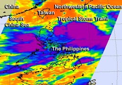
NASA's Aqua satellite passed over Tropical Storm Trami on Aug. 18 it looked at the storm in an infrared light and saw coldest cloud top temperatures and strong thunderstorms (purple) around the center and in a band of thunderstorms south of the center. <br>Image Credit: NASA JPL/Ed Olsen <br>
In a NASA image, Trami appears to be about two-thirds the size of the Philippines. Satellite data also indicates that the massive storm is now making a U-turn in the Northwestern Pacific Ocean, from a southeastern path to a northwestern path.
When NASA's Aqua satellite passed over Tropical Storm Trami on Aug. 18, the AIRS instrument aboard captured an infrared image that showed a large area of thunderstorm activity within the storm. The Aqua satellite passed over Trami at 17:29 UTC/1:29 p.m. EDT on Aug. 18. Aqua's Atmospheric Infrared Sounder instrument looked at the storm in an infrared light.
The infrared data showed the coldest cloud top temperatures circled the center of the storm and were in a strong band of thunderstorms wrapping into the center from the southwest. Trami continued to show the same organization on Aug. 19.
Multispectral satellite imagery on Aug. 19 revealed that the low-level center has been consolidating. Whenever a storm consolidates, it typically means that it can spin faster and winds increase. Data from Defense Meteorological Satellite Program polar orbiting satellites showed a near-complete eye-wall, and confirmed the strong band of thunderstorms over Trami's southern semi-circle.
At 1500 UTC/11 a.m. EDT, Tropical Storm Trami was located about 391 nautical miles south of Kadena Air Base near 20.3 north and 128.4 west. Trami was moving slowly to the northeast at 4 knots/4.6 mph/7.4 kph. Maximum sustained winds were near 50 knots/57.5 mph/92.6 kph.
Trami is expected to cross northern Taiwan as a typhoon on Aug. 21 before making a final landfall in southeastern China.
Text credit: Rob Gutro
NASA's Goddard Space Flight Center
Media Contact
All latest news from the category: Earth Sciences
Earth Sciences (also referred to as Geosciences), which deals with basic issues surrounding our planet, plays a vital role in the area of energy and raw materials supply.
Earth Sciences comprises subjects such as geology, geography, geological informatics, paleontology, mineralogy, petrography, crystallography, geophysics, geodesy, glaciology, cartography, photogrammetry, meteorology and seismology, early-warning systems, earthquake research and polar research.


Newest articles

Sea slugs inspire highly stretchable biomedical sensor
USC Viterbi School of Engineering researcher Hangbo Zhao presents findings on highly stretchable and customizable microneedles for application in fields including neuroscience, tissue engineering, and wearable bioelectronics. The revolution in…

Twisting and binding matter waves with photons in a cavity
Precisely measuring the energy states of individual atoms has been a historical challenge for physicists due to atomic recoil. When an atom interacts with a photon, the atom “recoils” in…

Nanotubes, nanoparticles, and antibodies detect tiny amounts of fentanyl
New sensor is six orders of magnitude more sensitive than the next best thing. A research team at Pitt led by Alexander Star, a chemistry professor in the Kenneth P. Dietrich…

