NASA Sees Tropical Storm Tembin Make Landfall in South Korea
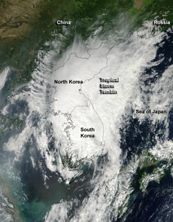
NASA's Aqua satellite's MODIS instrument captured this visible, true-color image of Tropical Storm Tembin at the time of landfall in southwestern South Korea. The image was captured at 04:45 UTC (12:45 a.m. EDT) on Aug. 30.<br>Credit: NASA Goddard /MODIS Rapid Response Team <br>
Tembin moved through the Myeongnyang Strait and made landfall on Aug. 30, 2012 at 0000 UTC (Aug. 29 at 8 p.m. EDT) in the southwestern tip of South Korea.
NASA's Aqua satellite's Moderate Resolution Imaging Spectroradiometer (MODIS) instrument captured a visible, true-color image of Tropical Storm Tembin around the time of landfall in southwestern South Korea. The image was captured at 04:45 UTC (12:45 a.m. EDT) on Aug. 30, and showed an elongated storm stretching from southwestern South Korea, over North Korea and into the Sea of Japan. Southwesterly wind shear has also taken its toll on Tembin as the storm has become elongated. When a storm is no longer circular, it loses its energy.
Satellite imagery also revealed that central convection (rising air that forms thunderstorms that make up Tembin) have been decaying rapidly.
On Aug. 30 at 0300 UTC (Aug. 29 at 11 p.m. EDT) Tropical Storm Tembin's maximum sustained winds were near 35 knots (40 mph/65 kmh). It was located about 85 nautical miles (97.8 miles/157.4 km) south of Kunsan Air Base, South Korea, near 35.5 North and 127.2 East. Tembin is moving to the north-northeast at 23 knots (26.4 mph/42.6 kmh) and forecasters at the Joint Typhoon Warning Center expect the storm to continue accelerating and drag across the rugged Taebaek Mountain Range, further weakening it.
Tembin is then is expected to briefly enter the Sea of Japan as an extra-tropical low pressure area and dissipate thereafter.
Text Credit: Rob Gutro
NASA Goddard Space Flight Center, Greenbelt, Md.
Media Contact
All latest news from the category: Earth Sciences
Earth Sciences (also referred to as Geosciences), which deals with basic issues surrounding our planet, plays a vital role in the area of energy and raw materials supply.
Earth Sciences comprises subjects such as geology, geography, geological informatics, paleontology, mineralogy, petrography, crystallography, geophysics, geodesy, glaciology, cartography, photogrammetry, meteorology and seismology, early-warning systems, earthquake research and polar research.


Newest articles

Recovering phosphorus from sewage sludge ash
Chemical and heat treatment of sewage sludge can recover phosphorus in a process that could help address the problem of diminishing supplies of phosphorus ores. Valuable supplies of phosphorus could…

Efficient, sustainable and cost-effective hybrid energy storage system for modern power grids
EU project HyFlow: Over three years of research, the consortium of the EU project HyFlow has successfully developed a highly efficient, sustainable, and cost-effective hybrid energy storage system (HESS) that…

After 25 years, researchers uncover genetic cause of rare neurological disease
Some families call it a trial of faith. Others just call it a curse. The progressive neurological disease known as spinocerebellar ataxia 4 (SCA4) is a rare condition, but its…

