NASA sees Tropical Storm Rosa's rains southeast of center
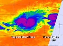
On Nov. 1, 2012 at 5:29 a.m. EDT the AIRS instrument aboard NASA's Aqua satellite took an infrared picture of Tropical Storm Rosa (left) and System 99E (right). The bulk of Rosa's rainfall was southwest of the storm's center.<br><br>Credit: NASA JPL, Ed Olsen<br>
When NASA's Aqua satellite flew over Tropical Storm Rosa at 5:41 a.m. EDT (0951 UTC) on Nov. 1, 2012 the Atmospheric Infrared Sounder (AIRS) instrument took an infrared picture of Tropical Storm Rosa and remnants of System 99E. The AIRS data showed the strongest convection (rising air that forms thunderstorms that make up a tropical cyclone) has been pushed southeast of Rosa's center as a result of northwesterly wind shear.
The convection in that quadrant was strong because the air pushed cloud tops of those thunderstorms to the top of the troposphere where temperatures are as cold as or colder than -63 Fahrenheit (-52 Celsius). Those are also areas where heavy rain typically falls. AIRS data showed that Rosa had become more disorganized, and that the banding of thunderstorms around the center was not as well-defined.
At 11 a.m. EDT Nov. 1, the center of Tropical Storm Rosa was located near latitude 13.9 north and longitude 118.4 west, about 825 miles (1,345 km) southwest of Cabo San Lucas, Mexico. Rosa had maximum sustained winds near 50 mph (85 kph) and was moving toward the west-southwest near 2 mph (4 kph). Rosa is expected to drift to the southwest and weaken over the next couple of days.
The low pressure area called System 99E that lies east of Rosa was also affected by wind shear and is no longer suspect for tropical development.
Media Contact
More Information:
http://www.nasa.govAll latest news from the category: Earth Sciences
Earth Sciences (also referred to as Geosciences), which deals with basic issues surrounding our planet, plays a vital role in the area of energy and raw materials supply.
Earth Sciences comprises subjects such as geology, geography, geological informatics, paleontology, mineralogy, petrography, crystallography, geophysics, geodesy, glaciology, cartography, photogrammetry, meteorology and seismology, early-warning systems, earthquake research and polar research.


Newest articles

Recovering phosphorus from sewage sludge ash
Chemical and heat treatment of sewage sludge can recover phosphorus in a process that could help address the problem of diminishing supplies of phosphorus ores. Valuable supplies of phosphorus could…

Efficient, sustainable and cost-effective hybrid energy storage system for modern power grids
EU project HyFlow: Over three years of research, the consortium of the EU project HyFlow has successfully developed a highly efficient, sustainable, and cost-effective hybrid energy storage system (HESS) that…

After 25 years, researchers uncover genetic cause of rare neurological disease
Some families call it a trial of faith. Others just call it a curse. The progressive neurological disease known as spinocerebellar ataxia 4 (SCA4) is a rare condition, but its…

