NASA sees Tropical Storm Kirogi headed for cooler waters
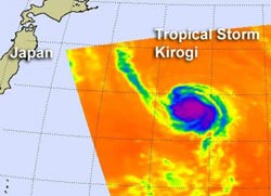
NASA's Aqua satellite passed over Tropical Storm Kirogi on Aug. 9 at 0241 UTC. The AIRS instrument captured an infrared image of the cloud temperatures that showed a concentrated area of strongest storms (purple) and heaviest rainfall around west of the center of circulation. AIRS shows cool waters in the direction Kirogi is heading, which will sap the storm's strength.<br>Credit: NASA JPL, Ed Olsen<br>
NASA's Aqua satellite passed over Tropical Storm Kirogi on August 9 at 0241 UTC. The Atmospheric Infrared Sounder (AIRS) instrument captured an infrared image of the cloud temperatures that showed a concentrated area of strongest storms and heaviest rainfall west of the center of circulation.
Vertical wind shear is currently at 10-15 knots, which is helping to prevent the storm from intensifying. The center of circulation also appears elongated from northwest to southeast in satellite imagery, which is a sign the storm is weakening. Whenever a tropical storm's center cannot “stack up” in the atmosphere, it begins to weaken.
On August 9, 2012 at 11 a.m. EDT (1500 UTC), Tropical Storm Kirogi had maximum sustained winds near 35 knots (40 mph/64.8 kmh). It was located about 550 nautical miles (633 miles/1,019 km) east-southeast of Misawa, Japan, near 38.5 North and 151.9 East. Kirogi was moving to the northwest at 20 knots (23 mph/37 kmh).
AIRS data indicates that the sea surface temperatures in the direction that Kirogi is moving are too cool to maintain a tropical cyclone. Kirogi is forecast to track over sea surface temperatures cooler than 25 Celsius once it nears 38 degrees north later on August 9, which will weaken the storm. The forecasters at the Joint Typhoon Warning Center note that the cooler waters will also help transform Kirogi's warm core to a cold core, making the storm into an extra-tropical one as it heads toward the two southernmost Kuril Islands.
Media Contact
More Information:
http://www.nasa.govAll latest news from the category: Earth Sciences
Earth Sciences (also referred to as Geosciences), which deals with basic issues surrounding our planet, plays a vital role in the area of energy and raw materials supply.
Earth Sciences comprises subjects such as geology, geography, geological informatics, paleontology, mineralogy, petrography, crystallography, geophysics, geodesy, glaciology, cartography, photogrammetry, meteorology and seismology, early-warning systems, earthquake research and polar research.


Newest articles

Roadmap to close the carbon cycle
A holistic approach to reach net-zero carbon emissions across the economy. A major approach to achieving net-zero carbon emissions relies on converting various parts of the economy, such as personal…

Cost-effective, high-capacity, and cyclable lithium-ion battery cathodes
Charge-recharge cycling of lithium-superrich iron oxide, a cost-effective and high-capacity cathode for new-generation lithium-ion batteries, can be greatly improved by doping with readily available mineral elements. The energy capacity and…

New regulator of eating behaviour identified
The rapidly escalating prevalence of overweight and obesity poses a significant medical challenge worldwide. In addition to people’s changing lifestyles, genetic factors also play a key role in the development…

