NASA sees record-breaking Julia being affected by Igor
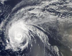
The Moderate Resolution Imaging Spectroradiometer (MODIS) instrument on NASA\'s Aqua satellite captured this view of Hurricane Julia\'s clouds on Sept. 16 at 1:35 p.m. EDT. Credit: NASA Goddard/MODIS Rapid Response Team<br>
As NASA's Aqua satellite flew over Hurricane Julia from space on Sept. 16 at 1:35 p.m. EDT, the Moderate Resolution Imaging Spectroradiometer (MODIS) instrument captured a visible image of the storm. In the MODIS image, Julia's eye was no longer visible and its center was cloud-filled.
Although Julia is weakening from Hurricane Igor's effects, she still broke a hurricane record in the Atlantic Ocean this week. The National Hurricane Center noted that Julia holds was the most intense hurricane to be so far east in the North Atlantic Ocean, when it was a Category 4 hurricane earlier this week. As of today, however, Julia is down to a Category one hurricane on the Saffir-Simpson hurricane scale.
At 11 a.m. EDT on Sept. 17, Hurricane Julia had maximum sustained winds near 85 mph. The center of Hurricane Julia was near latitude 24.2 north and longitude 46.7 west. That's about 1,500 miles southwest of the Azores. The Azores is a Portuguese archipelago in the Atlantic Ocean, about 930 miles west of Lisbon, Portugal and about 2,400 miles east from the U.S. east coast.
Julia is moving toward the west-northwest near 20 mph and is expected to turn to the turn toward the northwest with a decrease in forward speed is expected, followed by a turn north. Julia's estimated minimum central pressure is 981 millibars.
Julia is going to stay at sea, according to the forecasters at the National Hurricane Center in Miami, Fla. In fact, over the weekend she's expected to make a path in the shape of a boomerang in the eastern Atlantic and track northwest then turn northeast (and keep far away from Bermuda).
The NHC noted that northerly to northwesterly wind shear caused by Hurricane Igor's outflow will be increasing and adversely affecting Julia over the weekend. Hurricane computer forecast models are showing that Julia will be absorbed by the huge circulation of Hurricane Igor after the weekend.
Meanwhile, another area of low pressure has developed off the African coast, and forecasters give this system a 10 percent chance of developing into a tropical depression over the weekend. However, next week may be a different story.
Media Contact
More Information:
http://www.nasa.govAll latest news from the category: Earth Sciences
Earth Sciences (also referred to as Geosciences), which deals with basic issues surrounding our planet, plays a vital role in the area of energy and raw materials supply.
Earth Sciences comprises subjects such as geology, geography, geological informatics, paleontology, mineralogy, petrography, crystallography, geophysics, geodesy, glaciology, cartography, photogrammetry, meteorology and seismology, early-warning systems, earthquake research and polar research.


Newest articles

Recovering phosphorus from sewage sludge ash
Chemical and heat treatment of sewage sludge can recover phosphorus in a process that could help address the problem of diminishing supplies of phosphorus ores. Valuable supplies of phosphorus could…

Efficient, sustainable and cost-effective hybrid energy storage system for modern power grids
EU project HyFlow: Over three years of research, the consortium of the EU project HyFlow has successfully developed a highly efficient, sustainable, and cost-effective hybrid energy storage system (HESS) that…

After 25 years, researchers uncover genetic cause of rare neurological disease
Some families call it a trial of faith. Others just call it a curse. The progressive neurological disease known as spinocerebellar ataxia 4 (SCA4) is a rare condition, but its…

