NASA sees organizing tropical low pressure area near the Philippines
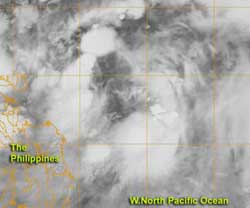
When NASA's Terra satellite passed over System 93W on July 27, 2012 at 10:14 p.m. (local time/Manila, Philippines) the center of the low appeared almost cloud-free, while broken bands of thunderstorms appeared to surround it from north to west to south.<br><br>Credit: Credit: NASA/NRL<br>
System 93W appears poised to become tropical storm Saola over the next two days if the organization continues. At 1400 UTC (10 a.m. EDT/U.S.; 10 p.m. Asia/Manila local time) System 93W had maximum sustained winds near 20 knots (23 mph/37 kmh). It was located about 395 nautical miles (454.6 miles/731.5 km) east-southeast of Manila, the Philippines, near 12.7 North latitude and 127.6 East longitude.
When NASA's Terra satellite passed overhead on July 27, 2012 at 1414 UTC (10:14 a.m. EDT/U.S.; 10:14 p.m. local time/Manila, Philippines) the Moderate Resolution Spectroradiometer (MODIS) instrument captured an infrared image of the low pressure area. The center of the low appeared almost cloud-free, while broken bands of thunderstorms appeared to surround it from north to west to south. The northeastern side of the storm appeared to be lacking in clouds.
The Joint Typhoon Warning Center noted that “upper level analysis indicates the vertical wind shear has weakened as the storm motion became in-phase with the upper level winds.” Weaker wind shear enables a low pressure area to strengthen, because it is not being battered by outside winds. In addition, sea surface temperatures are warm enough to contribute to the formation of a tropical depression (over 26.6 Celsius/80 Fahrenheit).
As a result of the weaker wind shear and improved banding of thunderstorms around the low's center, the Joint Typhoon Warning Center gave System 93W a “high chance” for becoming a tropical depression over the weekend of July 28-29.
Meanwhile, another low pressure system in the western North Pacific has a medium chance for development into a tropical depression. That low is located about 360 nautical miles (414 miles/666.7 km) east of Iwo-To, Japan, near 24.3 North and 147.8 East. On July 27, the showers and thunderstorms were being pushed to the east of the center due to wind shear.
Media Contact
More Information:
http://www.nasa.govAll latest news from the category: Earth Sciences
Earth Sciences (also referred to as Geosciences), which deals with basic issues surrounding our planet, plays a vital role in the area of energy and raw materials supply.
Earth Sciences comprises subjects such as geology, geography, geological informatics, paleontology, mineralogy, petrography, crystallography, geophysics, geodesy, glaciology, cartography, photogrammetry, meteorology and seismology, early-warning systems, earthquake research and polar research.


Newest articles

Trotting robots reveal emergence of animal gait transitions
A four-legged robot trained with machine learning by EPFL researchers has learned to avoid falls by spontaneously switching between walking, trotting, and pronking – a milestone for roboticists as well…

Innovation promises to prevent power pole-top fires
Engineers in Australia have found a new way to make power-pole insulators resistant to fire and electrical sparking, promising to prevent dangerous pole-top fires and reduce blackouts. Pole-top fires pose…

Possible alternative to antibiotics produced by bacteria
Antibacterial substance from staphylococci discovered with new mechanism of action against natural competitors. Many bacteria produce substances to gain an advantage over competitors in their highly competitive natural environment. Researchers…

