NASA sees the falling of Cyclone Felleng
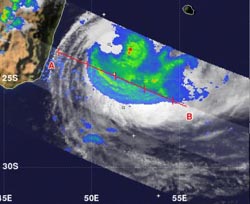
NASA's TRMM satellite flew over Cyclone Felleng on Feb. 1 at 11:48 a.m. EST and measured a small area of heavy rainfall (red) east of the center of circulation where rainfall was occurring at 2 inches (50 mm per hour). Most of the other precipitation was moderate, falling at a rate of 1.18 to 1.5 inches (30 to 40 mm) per hour.<br><br>Credit: NASA/SSAI, Hal Pierce<br>
NASA's Tropical Rainfall Measuring Mission (TRMM) satellite flew over Cyclone Felleng on Feb. 1 at 1648 UTC (11:48 a.m. EST) as it was exiting the Mozambique Channel and becoming extra-tropical.
TRMM measured a small area of heavy rainfall east of the center of circulation where rainfall was occurring at 2 inches (50 mm per hour). Most of the precipitation wrapped from northeast to south to west of the center and was moderate, falling at a rate of 1.18 to 1.5 inches (30 to 40 mm) per hour. The northwestern quadrant had very little rainfall at the time of the TRMM overpass.
The Joint Typhoon Warning Center (JTWC) , the organization that forecasts tropical cyclones in the Southern Indian Ocean, issued their final advisory on Cyclone Felleng on Feb. 3 at 2100 UTC (4 p.m. EST). At that time, Felleng's maximum sustained winds were near 40 knots (46 mph/74 kph. Felleng was located about 745 nautical miles (857 miles/1,380 km) south of La Reunion Island, near 33.4 South and 54.3 East. Felleng was moving to the south-southeast at 15 knots (17.2 mph/27.7 kph).
By Monday, Feb. 4 at 0600 UTC Felleng had completed its extra-tropical transition, and the storm's maximum sustained winds continued near 40 knots (46 mph/74 kph). Felleng's center had moved to 31.1 south and 52.8 east, about 605 nautical miles (696.2 miles/1,120 km) south-southwest of La Reunion Island. Felleng continues to move south-southeast in the open waters of the Southern Indian Ocean where it is expected to dissipate in the next couple of days.
Media Contact
More Information:
http://www.nasa.govAll latest news from the category: Earth Sciences
Earth Sciences (also referred to as Geosciences), which deals with basic issues surrounding our planet, plays a vital role in the area of energy and raw materials supply.
Earth Sciences comprises subjects such as geology, geography, geological informatics, paleontology, mineralogy, petrography, crystallography, geophysics, geodesy, glaciology, cartography, photogrammetry, meteorology and seismology, early-warning systems, earthquake research and polar research.


Newest articles
Economies take off with new airports
A global study by an SUTD researcher in collaboration with scientists from Japan explores the economic benefits of airport investment in emerging economies using nighttime satellite imagery. Be it for…

CAR T–cell immunotherapy targets
Pan-cancer analysis uncovers a new class of promising CAR T–cell immunotherapy targets. Scientists at St. Jude Children’s Research Hospital found 156 potential CAR targets across the brain and solid tumors,…
Stony coral tissue loss disease
… is shifting the ecological balance of Caribbean reefs. The outbreak of a deadly disease called stony coral tissue loss disease is destroying susceptible species of coral in the Caribbean…

