NASA sees a Tropical Storm Haliba 'sandwich'
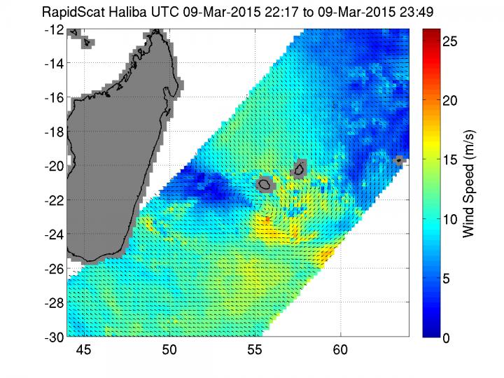
RapidScat measurements between March 9 from 22:17 to 23:49 UTC revealed Haliba's sustained winds dropped to 34 mph/55 kph) near the center and southern quadrant of the storm. Image Credit: NASA JPL, Doug Tyler
NASA and the Japan Aerospace Exploration Agency's Tropical Rainfall Measuring Mission or TRMM satellite passed above Tropical Storm Haliba on March 9 when its center was just west of La Reunion Island at 1035 UTC (6:25 a.m. EDT).
The bulk of precipitation appeared east of the center of Haliba's circulation making it appears as if the storm was between Reunion and Mauritius (which is northeast of Reunion). Westerly vertical wind shear was pushing the clouds and showers east of the center.
TRMM's Precipitation Radar (PR) instrument indicated that the heaviest rainfall of over 181 mm (7.1 inches) per hour was located in an intense rain band located northeast of Reunion Island.
TRMM's Precipitation Radar (PR) data showed the most powerful storms in this band of thunderstorms were reaching heights above 16.8 km (10.4 miles). Radar reflectivity values of 55.5 dBZ returned from heavy rainfall in that area are another proof of rainfall intensity in that area.
The International Space Station's RapidScat instrument captured a look at Tropical Cyclone Haliba's surface winds. RapidScat measured the winds later on March 9 from 22:17 to 23:49 UTC. By that time, Haliba had weakened.
Measurements revealed that sustained winds at the surface were as high as 15 meters per second (34 mph/55 kph) near the center and southern quadrant of the storm, indicating that the storm had dropped below tropical storm status and weakened to a depression.
By 0900 UTC on March 10, Tropical Cyclone Haliba's maximum sustained winds remained near 30 knots (34 mph/55 kph). It was centered near 23.7 south latitude and 55.3 east longitude, about 192 nautical miles (221 miles/356 km) south of St. Denis, La Reunion.
Tropical Depression Haliba was moving to the south-southwest at 8 knots (9.2 mph/14.8 kph).
The westerly vertical wind shear that affected Haliba on March 9 continued on March 10 and weakened the storm to a depression. The Joint Typhoon Warning Center expects the storm to maintain its strength over the next day until it dissipates.
Media Contact
All latest news from the category: Earth Sciences
Earth Sciences (also referred to as Geosciences), which deals with basic issues surrounding our planet, plays a vital role in the area of energy and raw materials supply.
Earth Sciences comprises subjects such as geology, geography, geological informatics, paleontology, mineralogy, petrography, crystallography, geophysics, geodesy, glaciology, cartography, photogrammetry, meteorology and seismology, early-warning systems, earthquake research and polar research.


Newest articles

Sea slugs inspire highly stretchable biomedical sensor
USC Viterbi School of Engineering researcher Hangbo Zhao presents findings on highly stretchable and customizable microneedles for application in fields including neuroscience, tissue engineering, and wearable bioelectronics. The revolution in…

Twisting and binding matter waves with photons in a cavity
Precisely measuring the energy states of individual atoms has been a historical challenge for physicists due to atomic recoil. When an atom interacts with a photon, the atom “recoils” in…

Nanotubes, nanoparticles, and antibodies detect tiny amounts of fentanyl
New sensor is six orders of magnitude more sensitive than the next best thing. A research team at Pitt led by Alexander Star, a chemistry professor in the Kenneth P. Dietrich…

