NASA satellites see wildfires across Colorado
The Moderate Resolution Imaging Spectroradiometer (MODIS) on NASA’s Aqua satellite captured this natural-color image on June 23, 2012. Red outlines approximate the locations of actively burning fires. The High Park and Weber Fires produced the largest plumes of smoke.<br><br>Credit: NASA Earth Observatory image by Jesse Allen using data obtained from the Land Atmosphere Near real-time Capability for EOS (LANCE).<br>
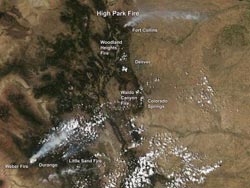
The Moderate Resolution Imaging Spectroradiometer (MODIS) on NASA's Aqua satellite captured this natural-color image on June 23, 2012. Red outlines approximate the locations of actively burning fires. The High Park and Weber Fires produced the largest plumes of smoke.
The High Park Fire continued to burn west of Fort Collins. Started by lightning on June 9, 2012, this blaze had consumed 83,205 acres (33,672 hectares), making it the second-largest fire in Colorado history, after the Hayman Fire that burned in 2002. As of June 25, more than 2,000 people were fighting the High Park Fire, and firefighters had it 45 percent contained, according to InciWeb. Nevertheless, The Denver Post reported that the fire had destroyed 248 homes, making it the most destructive in Colorado history, even if it was not the largest.
In the opposite corner of the state, the Weber Fire started around 4:15 p.m. on June 22. As of June 25, the fire had burned approximately 8,300 acres (3,400 hectares) and was being fought by 164 personnel. The cause was under investigation. The fire had high growth potential because of possible wind gusts from thunderstorms, InciWeb reported. On the other side of Durango, the Little Sand Fire had been burning for weeks after being started by a lightning strike on May 13. As of June 25, that fire had burned 21,616 acres (8,748 hectares), was being fought by nearly 200 people, and was 31 percent contained.
West of Colorado Springs, the Waldo Canyon Fire forced 11,000 people from their homes, many of them compelled to evacuate in the middle of the night on June 23. The fire started around noon on June 23, and by June 25 it had grown to 3,446 acres (1,395 hectares). InciWeb stated that 450 firefighters were battling the blaze, which retained the potential for rapid growth.
The Woodland Heights Fire just west of Estes Park was small but very destructive, consuming 27 acres (11 hectares) and destroying 22 homes, Denver's Channel 7 News reported. That fire was completely contained by the evening of June 24.
As fires burned, Colorado also coped with extreme heat. The Denver Post reported that Denver endured triple-digit temperatures June 22 through 24, and the National Weather Service forecast temperatures of at least 100 degrees Fahrenheit (38 degrees Celsius) for June 25 and 26, with temperatures in the upper 90s through June 29.
Colorado's fires have followed a dry spring. Although the state experienced unusually heavy snow in February, little snow followed in March and April, part of a larger pattern of low snowfall. By June 19, 2012, conditions throughout the state ranged from unusually dry to extreme drought, according to the U.S. Drought Monitor.
On June 25, 2012, Tim Mathewson, a fire meteorologist with the Rocky Mountain Area Coordination Center, remarked: “Current conditions are comparable to 2002 fire season, which was the worst in Colorado history. Fires haven't burned as many acres at this point, but the drought conditions and fuel conditions are right up there with the 2002 season, if not worse.”
For a non-labeled, high resolution image, visit: http://eoimages.gsfc.nasa.gov/images/imagerecords/78000/78367/colorado
_amo_2012175_lrg.jpg
Media Contact
More Information:
http://www.nasa.govAll latest news from the category: Earth Sciences
Earth Sciences (also referred to as Geosciences), which deals with basic issues surrounding our planet, plays a vital role in the area of energy and raw materials supply.
Earth Sciences comprises subjects such as geology, geography, geological informatics, paleontology, mineralogy, petrography, crystallography, geophysics, geodesy, glaciology, cartography, photogrammetry, meteorology and seismology, early-warning systems, earthquake research and polar research.


Newest articles

Looking inside battery cells
The power of combining different views. Lithium-Ion batteries presently are the ubiquitous source of electrical energy in mobile devices, and the key technology for e-mobility and energy storage. Massive interdisciplinary…

New snail-inspired robot can climb walls
A robot, designed to mimic the motion of a snail, has been developed by researchers at the University of Bristol. Adding to the increasing innovative new ways robots can navigate,…

New technique improves finishing time for 3D printed machine parts
North Carolina State University researchers have demonstrated a technique that allows people who manufacture metal machine parts with 3D printing technologies to conduct automated quality control of manufactured parts during…

