NASA satellite sees Tropical Cyclone Quang making landfall in Western Australia
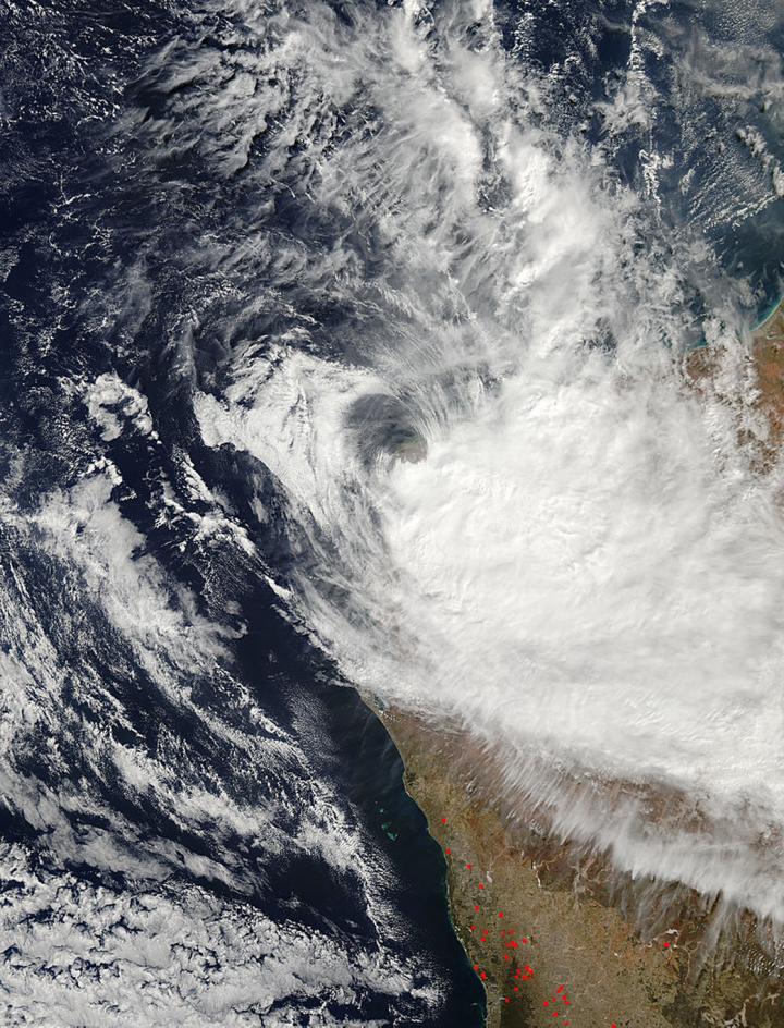
This visible image of Tropical Cyclone Quang was taken from the MODIS instrument aboard NASA's Aqua on May 1 at 06:20 UTC making landfall near Learmonth, Australia. Credit: NASA Goddard MODIS Rapid Response Team
The Moderate Resolution Imaging Spectroradiometer or MODIS instrument that flies aboard Aqua gathered data on Tropical Cyclone Quang on May 1 at 06:20 UTC (2:20 a.m. EDT).
The MODIS image showed that most of the thunderstorms associated with the cyclone were pushed southeast of the center from northwesterly wind shear, and that the other quadrants of the storm had very few thunderstorms.
The reason for a lack of thunderstorms and clouds north of the center is that dry air has wrapped around the northern quadrant. Multi-spectral imagery showed that the low level-circulation center had elongated.
On April 30 the International Space Station's RapidScat instrument measured Quang's sustained surface winds and observed the storm's strongest winds were in the southeastern quadrant. RapidScat measured winds from 21:38 UTC to 23:11 UTC (5:38 a.m. to 7:11 p.m. EDT).
Strongest winds were seen in the southern quadrant of the storm where a band of thunderstorms was wrapping into the center. Those winds reached speeds of 35 meters per second (78.9 mph/126 kph).
The Joint Typhoon Warning Center (JTWC) noted that the strongest winds were occurring over the southeastern quadrant on May 1 at 0600 UTC (2:00 a.m. EDT) just before the MODIS image was taken. Maximum sustained winds were near 70 knots (80.5 mph/129.6 kph).
The center of Quang was located near 21.7 south latitude and 114.0 east longitude, about 36 nautical miles north of Learmonth. It was moving to the southeast at 16 knots (18.4 mph/29.6 kph).
The JTWC forecast calls for Quang to continue weakening as vertical wind shear continues to increase. In addition, as the system tracks over land, the interaction with the topography will also add to the weakening. Quang is not expected to survive more than a day before dissipating.
Media Contact
All latest news from the category: Earth Sciences
Earth Sciences (also referred to as Geosciences), which deals with basic issues surrounding our planet, plays a vital role in the area of energy and raw materials supply.
Earth Sciences comprises subjects such as geology, geography, geological informatics, paleontology, mineralogy, petrography, crystallography, geophysics, geodesy, glaciology, cartography, photogrammetry, meteorology and seismology, early-warning systems, earthquake research and polar research.


Newest articles

Sea slugs inspire highly stretchable biomedical sensor
USC Viterbi School of Engineering researcher Hangbo Zhao presents findings on highly stretchable and customizable microneedles for application in fields including neuroscience, tissue engineering, and wearable bioelectronics. The revolution in…

Twisting and binding matter waves with photons in a cavity
Precisely measuring the energy states of individual atoms has been a historical challenge for physicists due to atomic recoil. When an atom interacts with a photon, the atom “recoils” in…

Nanotubes, nanoparticles, and antibodies detect tiny amounts of fentanyl
New sensor is six orders of magnitude more sensitive than the next best thing. A research team at Pitt led by Alexander Star, a chemistry professor in the Kenneth P. Dietrich…

