NASA Satellite Sees Pewa Become a Typhoon
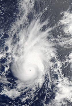
NASA's Aqua satellite passed over Typhoon Pewa on Aug. 19 at 01:05 UTC after it strengthened into a typhoon in the northwestern Pacific Ocean. The image shows that Pewa developed a small eye.<br><br>Image Credit: NASA Goddard MODIS Rapid Response<br>
On Sunday, Aug. 18, Pewa was a tropical storm when it crossed the International Date Line and moved from the Central Pacific to the Northwestern Pacific Ocean. Pewa now falls under the forecast authority of the Joint Typhoon Warning Center.
On Aug. 18, infrared satellite data showed that thunderstorm development and convection had slightly weakened, but the system remained well-organized. Forecasters at the Joint Typhoon Warning Center or JTWC, expected the slight weakening to quickly reverse itself as conditions around the storm improved. The JTWC forecast that Pewa would become a typhoon on Aug. 19, and it did.
NASA's Aqua satellite passed over Typhoon Pewa on Aug. 19 at 01:05 UTC shortly after it strengthened into a typhoon in the northwestern Pacific Ocean. The Moderate Resolution Imaging Spectroradiometer instrument image showed that Pewa developed a small eye surrounded by strong thunderstorms.
On Monday, Aug. 19 at 0900 GMT/5 a.m. EDT, Typhoon Pewa had maximum sustained winds near 65 knots/75 mph/120 kph. It was centered near 13.9 north and 177.9 east, about 726 nautical miles east-southeast of Wake Island. Pewa was moving to the northwest at 8 knots/9.2 mph/15 kph.
Pewa is expected to continue to intensify as it moves northwest. The JTWC expects Pewa to pass far to the northeast of Wake Island on Aug. 21 and 22.
Text credit: Rob Gutro
NASA's Goddard Space Flight Center
Media Contact
All latest news from the category: Earth Sciences
Earth Sciences (also referred to as Geosciences), which deals with basic issues surrounding our planet, plays a vital role in the area of energy and raw materials supply.
Earth Sciences comprises subjects such as geology, geography, geological informatics, paleontology, mineralogy, petrography, crystallography, geophysics, geodesy, glaciology, cartography, photogrammetry, meteorology and seismology, early-warning systems, earthquake research and polar research.


Newest articles

Sea slugs inspire highly stretchable biomedical sensor
USC Viterbi School of Engineering researcher Hangbo Zhao presents findings on highly stretchable and customizable microneedles for application in fields including neuroscience, tissue engineering, and wearable bioelectronics. The revolution in…

Twisting and binding matter waves with photons in a cavity
Precisely measuring the energy states of individual atoms has been a historical challenge for physicists due to atomic recoil. When an atom interacts with a photon, the atom “recoils” in…

Nanotubes, nanoparticles, and antibodies detect tiny amounts of fentanyl
New sensor is six orders of magnitude more sensitive than the next best thing. A research team at Pitt led by Alexander Star, a chemistry professor in the Kenneth P. Dietrich…

