NASA reveals heaviest rainfall in Tropical Storm Talim's southwestern side
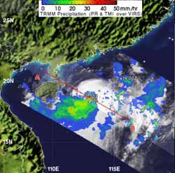
NASA's TRMM satellite captured a look at rainfall occurring in newborn Tropical Storm Talim in the South China Sea on June 18, 2012 at 0331 UTC. Areas in blue and green represent light to moderate rainfall, falling at a rate between 0.78 and 1.5 7inches (20-40 mm) . The bulk of the rainfall was occurring on the southern and western quadrants of the storm. Credit: Credit: NASA/SSAI, Hal Pierce<br>
NASA's Tropical Rainfall Measuring Mission (TRMM) satellite captured a look at rainfall occurring in newborn Tropical Storm Talim in the South China Sea on June 18, 2012 at 0331 UTC. Areas in blue and green represent light to moderate rainfall, falling at a rate between 0.78 and 1.5 7inches (20-40 mm). Some of the thunderstorms near the center of circulation were approaching 10 kilometers (6.2 miles) high.
NASA's Aqua satellite passed over Talim on June 18 at 0617 UTC (2:17 a.m. EDT), and captured infrared data about its cloudtop temperatures. Data showed that the western quadrant of the storm extended over Vietnam, bringing some rainfall there today, June 18.
The strongest thunderstorms, however, were still off-shore at the time, where cloud top temperatures exceeded -63F (-52C), and that's where the heaviest rainfall was occurring.
Forecasters expect that today's brush with Vietnam will be its only encounter with that country, as Talim is now heading northeast, and toward Taiwan. On June 18, 2012 at 1200 UTC (8 a.m. EDT/U.S.) maximum sustained winds were near 45 knots (52 mph/83 kph). Talim was crawling to the northeast at 3 knots (3.4 mph/5.5 kph) and is currently 185 nautical miles (213 miles/342.6 km) south-southwest of Hong Kong.
Sea surface temperatures in the South China Sea are warm enough to keep Talim going and forecasters expect Talim to strengthen on its journey to the northeast. Talim is expected to reach the Taiwan Strait in two days.
Media Contact
More Information:
http://www.nasa.govAll latest news from the category: Earth Sciences
Earth Sciences (also referred to as Geosciences), which deals with basic issues surrounding our planet, plays a vital role in the area of energy and raw materials supply.
Earth Sciences comprises subjects such as geology, geography, geological informatics, paleontology, mineralogy, petrography, crystallography, geophysics, geodesy, glaciology, cartography, photogrammetry, meteorology and seismology, early-warning systems, earthquake research and polar research.


Newest articles
Economies take off with new airports
A global study by an SUTD researcher in collaboration with scientists from Japan explores the economic benefits of airport investment in emerging economies using nighttime satellite imagery. Be it for…

CAR T–cell immunotherapy targets
Pan-cancer analysis uncovers a new class of promising CAR T–cell immunotherapy targets. Scientists at St. Jude Children’s Research Hospital found 156 potential CAR targets across the brain and solid tumors,…
Stony coral tissue loss disease
… is shifting the ecological balance of Caribbean reefs. The outbreak of a deadly disease called stony coral tissue loss disease is destroying susceptible species of coral in the Caribbean…

