NASA imagery shows wind shear hammering Cyclone Imelda
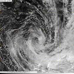
NASA's Aqua satellite passed over Tropical Cyclone Imelda on April 16 at 0943 UTC (5:43 a.m. EDT). Aqua captured this visible image that clearly showed the center of circulation, and most of the precipitation southeast of the center.<br><br>Credit: NASA/NRL<br>
NASA's Aqua satellite provided an image of Imelda that showed wind shear that has been hammering the storm, had pushed the bulk of the storm's precipitation southeast of the center.
Wind shear at higher levels has increased to as high as 30 knots (34.5 mph/55.5 kph), according to upper level analysis of the atmosphere that was conducted by the Joint Typhoon Warning Center. That stronger wind shear is weakening Imelda quickly.
NASA's Aqua satellite passed over Tropical Cyclone Imelda on April 16 at 0943 UTC (5:43 a.m. EDT) and the Moderate Resolution Imaging Spectroradiometer instrument captured a visible image of the storm that clearly showed most of the precipitation had been pushed southeast of the center from wind shear. Animated multispectral satellite imagery showed that the low level circulation center was fully exposed and there was no deep convection or strong thunderstorms developing over the previous 12 hours.
The last official warning on Imelda was issued on April 16 at 0900 UTC (5 a.m. EDT), when Imelda's maximum sustained winds had fallen to 35 knots (40 mph/65 kph). The weakening tropical storm was located near 21.2 south and 62.9 east, about 410 nautical miles (471.8 miles/ 759.3 km) east of La Reunion island and moving to the southeast at 5 knots (5.7 mph/9.2 kph).
Imelda is expected to continue weakening and should dissipate in the next day or two.
Media Contact
More Information:
http://www.nasa.govAll latest news from the category: Earth Sciences
Earth Sciences (also referred to as Geosciences), which deals with basic issues surrounding our planet, plays a vital role in the area of energy and raw materials supply.
Earth Sciences comprises subjects such as geology, geography, geological informatics, paleontology, mineralogy, petrography, crystallography, geophysics, geodesy, glaciology, cartography, photogrammetry, meteorology and seismology, early-warning systems, earthquake research and polar research.


Newest articles

Webb captures top of iconic horsehead nebula in unprecedented detail
NASA’s James Webb Space Telescope has captured the sharpest infrared images to date of a zoomed-in portion of one of the most distinctive objects in our skies, the Horsehead Nebula….

Cost-effective, high-capacity, and cyclable lithium-ion battery cathodes
Charge-recharge cycling of lithium-superrich iron oxide, a cost-effective and high-capacity cathode for new-generation lithium-ion batteries, can be greatly improved by doping with readily available mineral elements. The energy capacity and…

Novel genetic plant regeneration approach
…without the application of phytohormones. Researchers develop a novel plant regeneration approach by modulating the expression of genes that control plant cell differentiation. For ages now, plants have been the…

