NASA Gets a Stare from Cyclone Nilofar's 14 Mile-Wide Eye
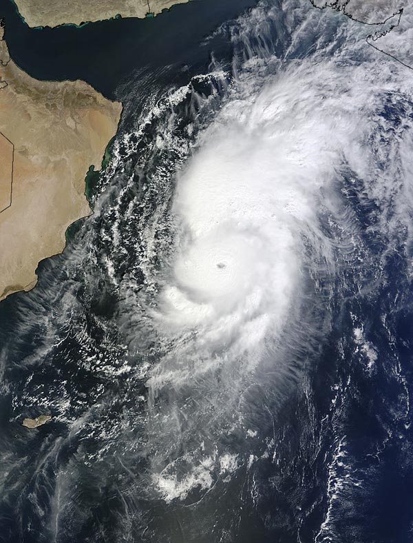
NASA's Terra satellite captured this image on Oct. 28 at 06:50 UTC (2:50 a.m. EDT) as Tropical Cyclone Nilofar was moving north in the Arabian Sea. Image Credit: NASA Goddard MODIS Rapid Response Team
On Oct. 28 at 06:50 UTC (2:50 a.m. EDT) the MODIS instrument aboard Terra captured a visible image of Tropical Cyclone Nilofar after it developed an eye while moving north in the Arabian Sea.
The 12 nautical mile (13.8 miles/22.2 km) wide eye was surrounded by powerful thunderstorms and bands of thunderstorms wrapped into the center from the eastern quadrant. A large band of thunderstorms stretched north-northeast of the center. The MODIS image showed that Nilofar was moving over open waters off-shore from Oman.
Tropical Cyclone Nilofar had maximum sustained winds near 115 knots (132 mph/213 kph) at 1500 UTC (11 a.m. EDT). Nilofar was centered near 17.1 north latitude and 61.8 east longitude, about 275 nautical miles (317 miles/509 km) southeast of Masirah Island. It was moving to the north at 9 knots (10.3 mph/16.6 kph).
On Oct. 28, the India Meteorological Department's Regionalized Specialized Meteorological Centre (RSMC) issued a Cyclone Alert, or “Yellow message” for north Gujarat coast. The bulletin noted that Nilofar was over the west-central Arabian Sea and was moving north while intensifying.
It was about 640 miles (1,030 km) southwest of Karachi, Pakistan and 509.5 miles (820 km) east-southeast of Salalah, Oman. The forecast calls for Nilofar to move to the northeast and cross north Gujarat and the Pakistan coast around Nayila on Nov. 1.
The Joint Typhoon Warning Center forecast calls for Nilofar to drop below hurricane force as it approaches northwestern India on Oct. 31. Nilofar is expected to be a tropical storm at the time of landfall.
The RSMC warned that Nilofar will bring heavy rains and strong winds along coastal districts of Saurashtra and Kutch from Oct. 31 to Nov. 1. IMB forecasts sustained winds near 28 to 34 mph (45 to 55 kph) with higher gusts. Sustained winds off the Gujarat coast on Oct. 31 can be expected between 50 to 56 mph (80 and 90 kph) with gusts to 62 mph (100 kph) at the time of landfall. Coastal conditions will deteriorate as the cyclone approaches, creating rough surf and dangerous ocean swells.
For updated forecasts and warnings, visit the RSMC website at: http://www.rsmcnewdelhi.imd.gov.in
Rob Gutro
NASA's Goddard Space Flight Center
Media Contact
More Information:
http://www.nasa.gov/content/goddard/nilofar-arabian-sea/All latest news from the category: Earth Sciences
Earth Sciences (also referred to as Geosciences), which deals with basic issues surrounding our planet, plays a vital role in the area of energy and raw materials supply.
Earth Sciences comprises subjects such as geology, geography, geological informatics, paleontology, mineralogy, petrography, crystallography, geophysics, geodesy, glaciology, cartography, photogrammetry, meteorology and seismology, early-warning systems, earthquake research and polar research.


Newest articles

Lower dose of mpox vaccine is safe
… and generates six-week antibody response equivalent to standard regimen. Study highlights need for defined markers of mpox immunity to inform public health use. A dose-sparing intradermal mpox vaccination regimen…

Efficient, sustainable and cost-effective hybrid energy storage system for modern power grids
EU project HyFlow: Over three years of research, the consortium of the EU project HyFlow has successfully developed a highly efficient, sustainable, and cost-effective hybrid energy storage system (HESS) that…

Safer alternative for an explosive reaction
The chemical industry has been using a reaction with explosive chemicals for over 100 years – now Mülheim scientists have discovered a safer alternative. The Ritter Group of the Max…

