NASA examines newly formed Tropical Depression 3W in 3-D
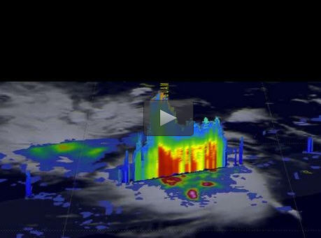
On April 14, 2017 at 1901 UTC (3:01 p.m. EDT) the GPM satellite found some of storms within Tropical Depression 03W were dropping rain at a rate of over 215 mm (8.5 inches) per hour. Some tall convective storm tops were reaching altitudes greater than 17.8 km (11.0 miles). Credits: NASA/JAXA, Hal Pierce
The GPM core observatory satellite had an excellent view of Tropical Depression 03W or TD03W when it flew over on April 14, 2017 at 1901 UTC (3:01 p.m. EDT). The GPM satellite found that the newly formed tropical depression contained some very powerful convective storms.
Intense storms in the middle of the organizing convective cluster were dropping precipitation at extreme rates. GPM's Microwave Imager (GMI) and Dual-Frequency Precipitation Radar (DPR) instruments unveiled tall convective storm towers on the eastern side of this cluster of storms that were dropping rain at a rate of over 215 mm (8.5 inches) per hour.
GPM is a joint mission between NASA and the Japanese space agency JAXA.
A 3-D examination of organizing TD03W's rainfall structure was constructed at NASA's Goddard Space Flight Center in Greenbelt, Maryland by using GPM's Radar (DPR Ku Band). Those data showed that tall convective storm tops on the left side of the cluster were reaching altitudes greater than 17.8 km (11.0 miles).
“Intense downpours in some of these storms were returning radar reflectivity values exceeding 59.7 dBZ to the satellite,” said Hal Pierce, who created the imagery and an animation at NASA Goddard.
“dBZ” means “decibel relative to Z.” It is a logarithmic unit used in weather radar to compare the equivalent reflectivity factor (Z) of a radar signal reflected off a remote object (like raindrops) to the return of a droplet of rain with a diameter of 1 millimeter.
On April 25, 2017 at 1500 UTC (11 a.m. EDT), TD03W had maximum sustained winds near 30 knots (34.5 mph/55.5 kph). It was centered near 13.1 degrees north latitude and 135.5 degrees east longitude, about 256 nautical miles northwest of Yap. TD03W was moving to the west-northwest at 4 knots (4.6 mph/7.4 kph).
The Joint Typhoon Warning Center (JTWC) predicts that TD03W will become slightly more powerful. Sustained maximum wind speeds are expected to reach about 45 knots (~52 mph), which would bring it to tropical storm strength as it curves the northeast.
JTWC then expects vertical wind shear to dampen further intensification and lead to its dissipation on about April 28, 2017.
Media Contact
All latest news from the category: Earth Sciences
Earth Sciences (also referred to as Geosciences), which deals with basic issues surrounding our planet, plays a vital role in the area of energy and raw materials supply.
Earth Sciences comprises subjects such as geology, geography, geological informatics, paleontology, mineralogy, petrography, crystallography, geophysics, geodesy, glaciology, cartography, photogrammetry, meteorology and seismology, early-warning systems, earthquake research and polar research.


Newest articles

Sea slugs inspire highly stretchable biomedical sensor
USC Viterbi School of Engineering researcher Hangbo Zhao presents findings on highly stretchable and customizable microneedles for application in fields including neuroscience, tissue engineering, and wearable bioelectronics. The revolution in…

Twisting and binding matter waves with photons in a cavity
Precisely measuring the energy states of individual atoms has been a historical challenge for physicists due to atomic recoil. When an atom interacts with a photon, the atom “recoils” in…

Nanotubes, nanoparticles, and antibodies detect tiny amounts of fentanyl
New sensor is six orders of magnitude more sensitive than the next best thing. A research team at Pitt led by Alexander Star, a chemistry professor in the Kenneth P. Dietrich…

