NASA examines deadly spring-like weather with GPM satellite
This IMERG 3-D Flyby animation shows the movement of storms from Feb. 25 through Mar. 1. Credits: NASA/JAXA, Hal Pierce
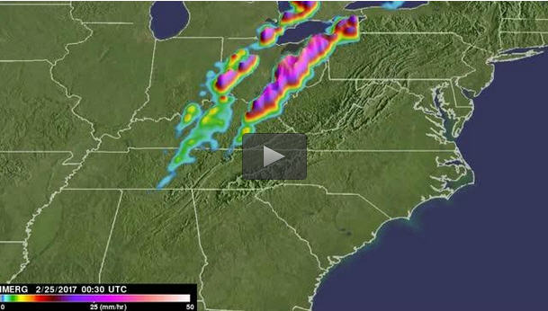
Record breaking warm temperatures this winter have caused plants to bloom early in the eastern United States. Unfortunately this has also resulted in the formation of spring-like severe thunderstorms and deadly tornadoes. Multiple tornado sightings were made in three of the last seven days. On Saturday February 25, 2017 destructive tornadoes were reported in Maryland, Pennsylvania and Massachusetts.
On February 28, twisters were reported in the states of Arkansas, Iowa, Illinois and Michigan. Three people were killed in Illinois and four others were injured in Arkansas with this tornado outbreak. Severe weather on March 1, 2017 also included reports of tornado sightings in Ohio, Tennessee, West Virginia, Kentucky and Georgia.
Integrated Multi-satellitE Retrievals for GPM or IMERG data were used to show the rainfall that occurred during the past week. The analysis was done at NASA's Goddard Space Flight Center in Greenbelt, Maryland. Intense downpours from storms over this period resulted in flash floods in several states.
The GPM core observatory satellite had a good view of severe weather as it moved into the Appalachian Mountains on March 1, 2017 at 1525 UTC (10:25 a.m. EST). The GPM satellite measures rain and snow using the GPM Microwave Imager (GMI) and Dual-Frequency Precipitation Radar (DPR) instruments.
GPM's DPR measured rain falling at a rate of over 6.3 inches (159 mm) per hour as powerful storms moved through Tennessee and Kentucky. Storm top heights of over 32,800 feet (9.8 km) were found by GPM's radar as it sliced through those intense thunderstorms.
Due to above average temperatures, frozen precipitation, other than hail, was unusual over the eastern United States in the GPM analysis. GPM's radar data (DPR) showed that the average height of the freezing level was above 9,800 feet (3 kilometers).
In Alabama, the freezing level was much higher up. It was shown by GPM's data to be higher than 13,123 feet (4 kilometers).
GPM is a joint mission between NASA and the Japanese space agency JAXA. For more information about GPM, visit: http://www.
For forecasts, visit the National Weather Service's Weather Prediction Center website: http://www.
Media Contact
All latest news from the category: Earth Sciences
Earth Sciences (also referred to as Geosciences), which deals with basic issues surrounding our planet, plays a vital role in the area of energy and raw materials supply.
Earth Sciences comprises subjects such as geology, geography, geological informatics, paleontology, mineralogy, petrography, crystallography, geophysics, geodesy, glaciology, cartography, photogrammetry, meteorology and seismology, early-warning systems, earthquake research and polar research.


Newest articles

Sea slugs inspire highly stretchable biomedical sensor
USC Viterbi School of Engineering researcher Hangbo Zhao presents findings on highly stretchable and customizable microneedles for application in fields including neuroscience, tissue engineering, and wearable bioelectronics. The revolution in…

Twisting and binding matter waves with photons in a cavity
Precisely measuring the energy states of individual atoms has been a historical challenge for physicists due to atomic recoil. When an atom interacts with a photon, the atom “recoils” in…

Nanotubes, nanoparticles, and antibodies detect tiny amounts of fentanyl
New sensor is six orders of magnitude more sensitive than the next best thing. A research team at Pitt led by Alexander Star, a chemistry professor in the Kenneth P. Dietrich…

